Luck Of The Irish.
SURF:
Boy were we lucky this week.

Heaps of surf and great weather resulted in firing waves up and down the coast.

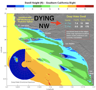
For tomorrow, the NW we've been enjoying will be a shell of it's former self but we do have a new fun SW filling in on Saturday as well as NW windswell from a cold front moving down the coast. Look for fun chest high combo surf later in the day.

For Sunday, forecast models the past few days have been showing a windy cold front hitting So-Cal and the surf should be a mess. Not much rain with this system but it will be bumpy in the line ups. And here's the tides, sun, and water temps for the next few days:
- Sunrise and sunset for Saturday:
- 6:53 AM sunrise
- 7:00 PM sunset

- Water temps have warmed slightly to 62. Is winter officially over? Jinx!

- And we've got a fair amount of tides this weekend:
- 3' at sunrise
- 5' late morning
- 0' late afternoon
- 2' at sunset
FORECAST:
Once the storm exits on Sunday, Monday looks to be fun with dropping shoulder high NW and a touch of leftover SW- and clean conditions. May have to flip on the ol' EBS. Tuesday/Wednesday look to be transition days with small SW/NW.
Later in the week, we've got more fun SW building towards Thursday into Friday with chest high sets in N SD County and shoulder high waves in the OC. Models show more storms off Antarctica trying to take shape but nothing concrete yet. Regardless, we're heading towards SW swell season.

Also on Friday, we have more shoulder high NW filling in. Along with the SW swell- could be fun. May have to flip on the ol' EBS- again. As long as the weather cooperates next week, we should have fun surf Monday and Friday.
WEATHER:

Know what the last day of winter is? Correct, March 20th. And the atmosphere is going to give us one last gasp of cold blustery weather. Friday looks to be the last nice day this week before Saturday transitions to more clouds and Sunday is breezy with just a chance of showers- at most 1/10". Next week high pressure is in control and we're back to temps in the low 70's during the day and low 50's at night. If anything changes between now and then, make sure to follow North County Surf on Twitter!
BEST BET:
Monday with clean combo swell or next Friday with clean combo swell!
NEWS OF THE WEEK:

Just when I though La Nina (lack of rain, colder than usual ocean temps) was fading away- looks like it may be overstaying its welcome! Welcome to summer in a fullsuit! Here's the latest from the National Oceanic and Atmospheric Administration (NOAA):
Three Pack:
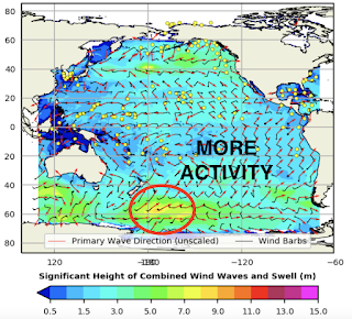
All good things come in threes. Well, depending on your opinion of La Niña, maybe not all good things, as La Niña—the cool phase of the El Niño-Southern Oscillation climate pattern—reasserted itself in the tropical Pacific this past month with some of the strongest atmosphere-ocean coupling of our double-dip La Niñas so far (winters of 2020-21 and 2021-22). La Niña is now favored to continue into the Northern Hemisphere summer 2022, with nearly equal chances of ENSO-neutral or La Niña thereafter. Is a La Niña three-peat in the offing?
Three-dimensional
Three Pack:
All good things come in threes. Well, depending on your opinion of La Niña, maybe not all good things, as La Niña—the cool phase of the El Niño-Southern Oscillation climate pattern—reasserted itself in the tropical Pacific this past month with some of the strongest atmosphere-ocean coupling of our double-dip La Niñas so far (winters of 2020-21 and 2021-22). La Niña is now favored to continue into the Northern Hemisphere summer 2022, with nearly equal chances of ENSO-neutral or La Niña thereafter. Is a La Niña three-peat in the offing?
Three-dimensional

Wait- La Niña strengthened in February? It did, despite the fact that sea surface temperatures in the key monitoring region of the tropical Pacific, the Niño-3.4 region, appear to have bottomed out in December, with a monthly value of -1.1°C (ERSSTv5 data set). Since then, the monthly values have warmed slightly, though February 2022 remained chilly at -0.9 °C. However, the February average smoothed out some notable variability: the weekly average Niño-3.4 index was -0.6 °C at the beginning of February and then decreased to -1.1 °C in the past week. Quite a dive!
Confused by all the numbers for presumably the same Niño-3.4 sea surface temperature index? Don’t be- averages for shorter time spans can fluctuate around a lot more than longer averaging periods. This is the difference between weather and climate. Day-to-day or week-to-week weather can change a lot relative to monthly and longer seasonal climate averages, which do not vary as much. Even as the weekly and monthly values have jumped around, the Oceanic Niño Index (ONI), NOAA’s official measure of ENSO, has remained constant at -1.0°C for the third, overlapping season in a row.
One of the major challenges in ENSO prediction is trying to untangle meaningful seasonal swings in the tropical climate from the shorter-term noise of tropical weather. In February, along with cooling off of sea surface temperatures, we saw a stronger Pacific Walker circulation: a strengthening of trade winds along the surface of the equator (blowing from east-to-west), stronger winds in the upper tropical atmosphere (that blow from west to east), significant drying over the Date Line, and increased rainfall anomalies over the Maritime Continent. All of these features are consistent with a healthy La Niña.
In fact, by some of our atmospheric measures—the Equatorial Southern Oscillation Index and Central Pacific Outgoing Longwave Radiation index (a measure of equatorial rainfall)—we saw some of the largest monthly values dating back to the start of the first La Niña event in the autumn of 2020! The Pacific Walker circulation was clearly juiced up in the past month and is probably why we saw weekly Niño-3.4 sea surface temperatures take a tumble.
With that said, one month doesn’t make an entire season, and it may have been a short-term swerve on the road to the dissipation of La Niña, as it typically does, through the spring and summer. It’s enough to have at least slowed down La Niña’s exit from the global climate stage, but does it portend more meaningful change going forward? We’ll get back to that later.
Three-legged Race

What does the continuation of La Niña mean for impacts during the March-May season over the contiguous United States? As regular blog readers know, the two biggest drivers of seasonal climate outlooks are ENSO and climate trends.
As one might expect, NOAA CPC’s official seasonal outlooks for March-May 2022 resemble the patterns above with some exceptions. In general, above-average temperatures are favored over a large part of the contiguous U.S., with the exception of the northwestern U.S., where below-average temperatures are more likely. Above-median precipitation is expected over the northwestern U.S. and the Ohio and Tennessee valleys. Below-median precipitation is favored over most of the southern U.S., extending northward into Utah, Colorado, and parts of the western Great Plains.
In addition to these potential temperature and precipitation anomalies, it is also worth noting that during La Niña, springtime severe weather can be more active in parts of the southern/southeastern United States.
Three’s A Crowd

Despite a few forecast models suggesting otherwise, below-average sea surface temperature patterns are likely to weaken across the tropical Pacific as we go through the spring, but it’s still an open question how much they will weaken. Will they weaken enough to eventually return to ENSO-neutral (near average conditions across the tropical Pacific)? And when would that happen?
This month the crystal ball became blurrier, with a 54% chance that La Niña persists into June-August 2022. And, after that, it’s pretty much a split between ENSO-neutral and La Niña through the fall, with neither outcome exceeding a 50% probability (and El Niño still has a 10-15% chance!). Thus, reading between the lines, odds for a La Niña three-peat have gone up, but nowhere near certainty. Keep in mind, the accuracy of ENSO forecasts made this time of year are, well…not so great.
Also, La Niña three-peats (triple dips?) are very rare—only two exist in our more reliable historical record going back to 1950 and both occurred after major El Niño events, which our current event did not. It is also interesting that out of the eight double-dip La Niñas in our historical record, three ended up evolving into an El Niño for the third winter and the remaining three ended up on the cooler side, close to La Niña thresholds, but were ultimately classified as ENSO-neutral winters.
To get to a third consecutive La Niña winter we would need to see ongoing, enhanced easterly trade winds and, also, the replenishment of below-average temperature “fuel” in the subsurface equatorial Pacific Ocean. In February, at least, we saw some trends in this direction.
So in conclusion... looks like signs are pointing towards a 3rd straight year of a La Nina winter. I guess I can put that 9'0" rhino chaser back in the rafters.
PIC OF THE WEEK:

When Irish eyes are smiling, they must have been surfing Lahinch.
Keep Surfing,
Michael W. Glenn
Better Late Than Never
Whippersnapper
2002 Irish National Surfing Champion Runner-up
Michael W. Glenn
Better Late Than Never
Whippersnapper
2002 Irish National Surfing Champion Runner-up