
Impatience Is A Virtue
SURF:
Not much surf this past week EXCEPT for that funky day on Saturday. Just when it looked like all hope was lost during the storm, the wind stopped, the surf cleaned up, and there was surprisingly good surf for a short window on Saturday. And then that was it. I'm starting to get impatient. For the upcoming weekend, we may have a similar situation- or we may not- just depends how the storm tonight behaves.

NW wind/groundswell is filling in off Central CA today and we'll see head high surf on Friday (bigger towards SD)- but who knows how the wind will behave. For Saturday, the skies clear and the surf drops to the chest high range. Sunday is clean and small. And here’s the sun, tides, and water temps for the upcoming weekend:
- Sunrise and sunset:
- 6:29 AM sunrise (paddle out at 6:15?)
- 7:13 PM sunset (paddle in at 7:30)?

- Water temps are 60 if you're lucky.

- Tides are swinging for the fences this weekend:
- about 4' at sunrise
- up to 5.5' at breakfast
- down to -0.5' mid-afternoon
- and up to 4' again at sunset
FORECAST:
For Monday, a weak cold front moves N of us and will kick up the NW windswell again to the chest high range.

For late Tuesday, a small SW fills in for waist high waves in north county SD and a touch bigger in the OC. After that, the N Pacific looks to be going into hibernation mode while the S Pacific MAY be coming to life.

A storm today off Antarctica looks to send chest high sets our way around the 13th from the S while better storms could form in the coming week and send good SW swells around the 17th and 20th. If anything changes between now and then, make sure to follow North County Surf on Twitter.
WEATHER:
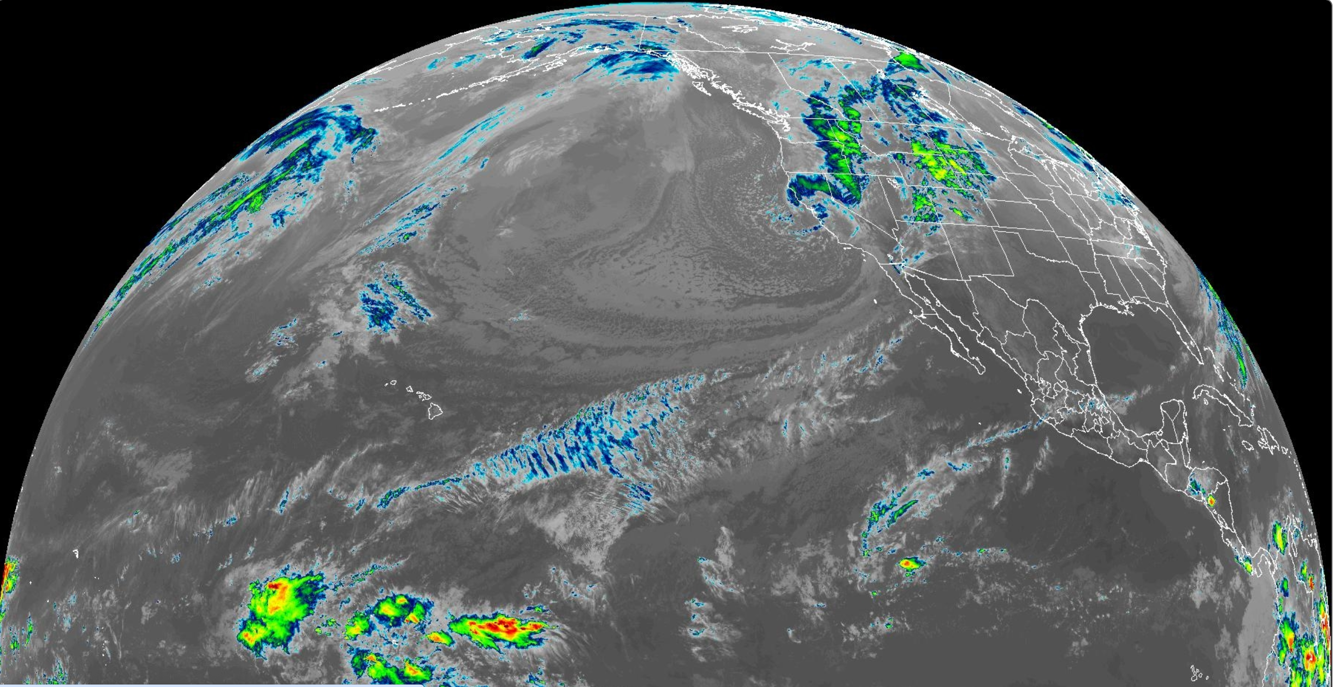
A new "storm" is headed our way tonight- but it's nothing like last weekend. Look for a breezy day tomorrow with up to 1/4" of rain (for comparison's sake, last Saturday's storm dropped up to 2" of rain) along with chilly temps (for SD). Saturday is a transition day and Sunday is sunny and cool. Monday has a touch more clouds- then sunny skies are here again for the rest of the week! And here's what we have on tap for the next several days:
- Friday: Breezy with showers. Temps 56/46.
- Saturday: Clearing. Temps 60/45.
- Sunday: Sunny and cool. Temps 60/50.
- Monday: Mostly cloudy. Temps 62/48.
- Tuesday to until forever? Sunny. Temps 71/53.
BEST BET:
- Friday if you can find a clean window as it will be the biggest day in quite awhile.
- Saturday- smaller and cleaner.
- Wednesday with small SW but clean.
NEWS OF THE WEEK:

THIS WEEKEND IN WEATHER HISTORY!
2019:
A storm system brought strong winds to the mountains and deserts. A wind gust of 98 mph was clocked at Burns Canyon.
2012:
A strong cold front moved through the region, bringing strong mountain wave activity to the deserts. Winds gusted as high as 80 mph, resulting in road closures and damage to a few mobile homes.
2010:
Two funnel clouds were observed by the John Wayne Airport. Five funnel clouds were observed by a police helicopter off the coast of Crystal Cove.
2000:
A storm that started on 3/4 and ended on this day brought up to 17 inches of snow in 24 hours to the mountains. 14 inches fell at Forest Falls. Strong thunderstorms produced golf ball size hail at Garden Grove, Santa Ana, and Running Springs. Strong thunderstorm wind gusts measured 60 mph at Huntington Beach. Property was damaged and trees were downed along the coast from Huntington Beach to Sunset Cliffs.
1995:
Heavy rain that started on 3/5 and ended on this day dropped six inches in 24 hours and 10.34 inches in 48 hours at Idyllwild. 10.52 inches fell in 48 hours at Palomar Mountain. On this day eight inches of rain fell at Palomar Mountain, the third greatest daily amount on record. Floodwaters washed out a stretch of I-5, closing it for over a week. The overall toll from a series of Pacific storms: 27 killed, $3 billion in damage, and 10,000 homes damaged.
1992:
A series of storms that began on 3/1 and ended on 3/7 brought one to four inches of rainfall and local flooding.
1983:
This day marked the end of nine consecutive days (the most on record) of measurable precipitation in San Diego, which started on 2/26. This also occurred on 2/13-21/1980 and 2/5-13/1978. This day marked the end of 11 consecutive days (the most on record) of measurable precipitation in Idyllwild, a streak that started on 2/24. 1968: Heavy rain that began on this day ended on 3/8. One drowning death resulted. There was local flooding and damage to buildings, homes, and schools. Landslides closed several highways.
PIC OF THE WEEK:

It's almost Mainland Mexico time. Can we get The Search 'CT event back?!
Keep Surfing,
Michael W. Glenn
Healthy, Wealthy, & Wise
No One's Beating UConn
Inventor Of The Tri-Skeg Surfboard
Michael W. Glenn
Healthy, Wealthy, & Wise
No One's Beating UConn
Inventor Of The Tri-Skeg Surfboard