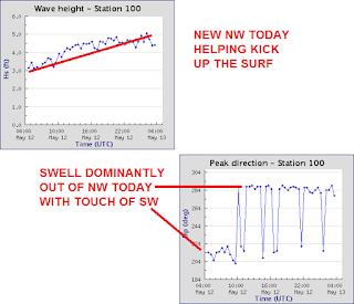
Had some fun small surf the past few days with seasonal weather and water temps slightly above normal.
New NW filled in today and met up with slowly building SW swell for chest high waves and shoulder high sets this evening. Winds weren't much of a problem as we had typical SSW winds for May.
I've been watching some S swell slowly make it's way up the Americas this past week and we'll start to see sets later on tomorrow and peak on Thursday. Look for head high sets from the SW as well as building NW windswell late Thursday.
The source of that building NW windswell is from a late late late season storm approaching late Thursday into Friday. As we approach summer, the Aleutians will be dumping a storm on us with 3/4"of rain and 6" of snow in our mountains above 7,000'. We're still a long way off to hitting our normal 10" of rain for the season, but it will at least hold off the fire weather for awhile.
As the storm blows through on Friday and makes a mess of things around here, look or the NW windswell to hit the head high+ range. Not worth surfing unfortunately as the seas will be a mess and the water will be filthy. Things clean up by Sunday but the surf also disappears along with the clouds.
After the mix of swells this week, next week is looking suspect. Not much NW on the charts and the southern hemisphere is a little confused. Lots of activity in the forecast but not much organization. At this point in time, we should have some background chest high SW next weekend. Hopefully it will be bigger but the storms need to get their act together first!
Water temps are holding at 64 degrees (but should drop after the weekend once the NW winds kick in from Friday's storm) and tides the next few days are 4' at sunrise, down to 0' at lunch, and back up to 5' at sunset. In a nutshell, make sure to get some surf early Thursday before the storm wreaks havoc on your weekend surf plans!


