
My head's gonna explode.
SURF:
Lots of good SW swell this past week even though May Gray was a little strong for a few days. We're starting to see some sunshine in the afternoons finally and it's shining on the good swell we've had the past few days.


FORECAST:

So why's my head gonna explode?! ALLLLLLLLLLL kinds of stuff happening to the south of us right now (as well as NOAA's 2015 summer hurricane forecast- more on that below). Even though the our weekend swell will be on a down trend, Monday will make up for that. First up is a solid storm off Antarctica last week that is sent us a good SW swell for Monday afternoon. Look for shoulder high surf to show by sundown and and actually peak on Thursday with well overhead sets.
WEATHER:

Here's a question: Would you rather have 90 degree beach weather with a chance of brush fires (i.e. last May) or May Gray at the beaches with temps in the mid-60's and drizzle (this May)? Knowing the horror and doom of the brush fires in north county SD last year, I'll take drizzle and the gloom this year. High pressure is building today and will give us a little more sunshine at the beaches this weekend but the forecast is tricky as inland it will be close to 90 and the coast may see socked in fog. Hopefully we'll see a little sun by mid-afternoon around here. On Monday we have another weak trough setting up shop in southern CA and the return of thick May Gray will rear it's head for the beginning of June.
BEST BET:
Pretty much Tuesday to Thursday. Clear your schedule.
NEWS OF THE WEEK:

Last week I discussed the strong likelihood that the El Nino this year may hang around through our upcoming winter (click here).
And what that may mean for our upcoming summer (click here).
In case you missed it, here's a condensed version of last year's hurricane activity:
The pseudo El Nino this past winter didn't do anything for our drought but it sure did make it's presence felt this past summer. As you know, our water temps were about 5 degrees warmer than normal which translated to warmer water at the equator and overall the 2014 season was extremely active in the Eastern Pacific off mainland Mexico and Baja; the number of named storms, hurricanes, and major hurricanes was well above average. Based on data from 1981-2010 climatology records, the seasonal activity averages for hurricanes off Mainland Mex/Baja are:
-15 named storms
-8 hurricanes
-and 3 to 4 major hurricanes.
And 2014 was well above those averages:

-20 named storms formed of which (5 more than normal)
-14 became hurricanes (6 more than normal)
-and 8 of those reached major hurricane strength (4 to 5 more than normal)
The National Oceanic and Atmospheric Administration (NOAA) just issued it's summer 2015 hurricane outlook for the Eastern Pacific. Their prediction is for a 70 percent chance of an above-normal hurricane season. I love it. That outlook calls for a 70 percent probability of:
-15-22 named storms (vs. an average of 15 and last summer's 20)
-7-12 are expected to become hurricanes (vs. an average of 8 and last summer's 14)
-and 5-8 major hurricanes (vs. an average of 3-4 and last summer's 8)
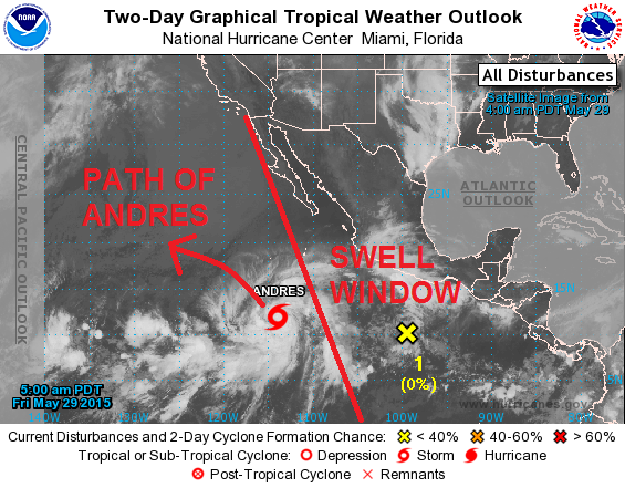
Last year was better than could have been expected and NOAA reflected that in their forecast this year as they're looking at summer 2015 with a grain of salt (i.e. last year we had 8 major hurricanes and NOAA thinks that's the upper end of the scale this year). Regardless, we should be in for an above average hurricane season this year- and if Tropical Storm Andres (soon to be Hurricane Andres) is any indication (i.e. we're still 3 weeks before summer starts), we're on the right track.
PIC OF THE WEEK:

Another reason gold is always a good buy.
Keep Surfing,
Michael W. Glenn
King For A Day
Paid For the Stones Gig At Belly Up
Designing a Bikini Line With McTavish For Vee Bottom Shapes