Thursday, August 27, 2015
THE Surf Report- Early Edition
The weekend can't come soon enough.
SURF:
Been pretty boring around here lately. I mean, getting a few tropical showers here and there was cool this week, but I need some surf! Looks like our prayers will be answered this weekend- and good weather to boot. AND warm water temps (Scripps Pier hit 78 today for what it's worth).
Look for a slow start tomorrow morning then a new SW swell starts to build all day and peak late Saturday for shoulder high sets. Models also show a little NW too by Sunday so the beach breaks should be fun.
Tides the next few days are 3' at sunrise, up to 5' at 9am, down to 1' around 3pm and up to 6' at sunset.
FORECAST:
Finally something to talk about! After the weekend of fun SW swell, it keeps rolling into next week with another boost on Tuesday for head high sets. That starts to taper off by Thursday.
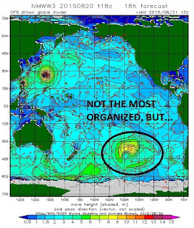
Models last week showed a big storm forming off New Zealand but it soon fizzled and turned into an average storm. Average meaning head high+ SW swell for us over Labor Day weekend. And a touch of NW. God bless 3 day weekends.
We also have soon to be Hurricane Jimena tonight spinning half way between Cabo and Hawaii with winds of 70 mph. Good news is that it's forecasted to MAYBE hit a maximum Category 5 hurricane next week with winds near 150 mph. Solid. Bad news is that it's moving away from us. Good news is that the models show it stalling before it hits Hawaii- so maybe- just maybe- we'll get some surf from it over Labor Day Weekend too- if you can find it underneath that good SW swell. Speaking of hurricanes, Hawaii will be surrounded by 3 of them early next week. Yikes.
Back here in California, we also have more S swell on the charts from the southern hemisphere that may show up around September 9th for shoulder high waves. Lots of good stuff happening. I love that it's flat around here for 2 weeks and then the next two weeks is going to be fun. Feast or famine. Some may call it annoying. Make sure to keep up to date on the waves/weather at Twitter/North County Surf.
WEATHER:
Now THIS feels like August. Temps in the mid-80's, humidity, a lack of low clouds/fog, and thunderstorms in the desert. We have 2 more days like that around here before a weak low pressure system in northern California starts to influence our weather down here. Look for the clouds to return in the nights and mornings on Sunday and last into most of next week. Temps will return to normal too with mid-70's at the beaches.
BEST BET:
Like a kid in a candy shop: Maybe Saturday with peaking SW swell and good weather. Or Tuesday with a bump in size from the SW. OR... next weekend with bigger SW swell and potentially hurricane swell.
NEWS OF THE WEEK:
Noticed how we started our hurricane season with a BANG and now all the storms are over towards Hawaii and Japan? What gives?! I want answers!
A couple theories actually. We’ve had a stubborn sub-tropical high pressure system below us the past few months and the storms haven’t had a chance to form until they get out from under it- which happens to be near Hawaii. Another theory is the warm water in the Pacific is in a U-shape; so once the clouds move off Mainland Mexico and finally get their act together, they follow the path of the U-shape and eventually hit full steam near Hawaii. So what does this mean for Hawaii? Lots of surf, lots of rain, and the threat of hurricanes I guess.
So much rain in fact that the islands have already recorded rainfall well above normal for the month of August—Honolulu alone saw 3.6 inches of rain on Monday, more than six times the typical monthly tally. A series of storms that so far have not caused significant damage but have drenched Hawaii and they’ve had to dodge 11 storms so far this summer- with numbers 12 (Ignacio) and 13 (Jimena) on the horizon.
Although Honolulu’s recent downpours caused some flooding, road and beach closings, and overflowing sewers, it hasn’t been all bad news. Like the rest of us in California, almost a third of the Aloha State is in a drought. Water-wise that is, not wave-wise.
PIC OF THE WEEK:
Don't cringe and say "Not another left for the Pic of the Week"! In fact, I counted up how many rights and lefts I've had on the Pic of the Week, and there have been 3,489 rights and only 1,776 lefts. So for the next 1,713 Pics of the Week (32 years give or take a few months), I'll only be showing lefts as to not give it an inferiority complex to the rights.
Keep Surfing,
Michael W. Glenn
Unfazed
Patched Things Up Between Kobe and Shaq
Doin' Crossfit With Laird Tomorrow


