
Hit the reset button.
SURF:
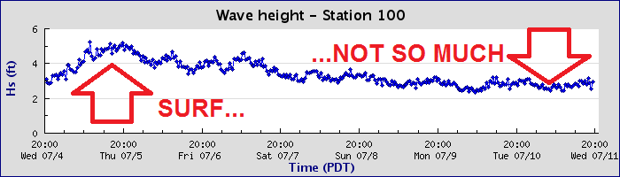
Great surf, weather, and water temps the past few weeks have been replaced by small surf, semi-great weather, and still warm water temps.

Looks like we're getting a boost from the SSW Thursday afternoon that will last into Sunday morning. Nothing big but we should be back to chest high surf Friday/Saturday and the OC will have shoulder high sets. We also have a little NW windswell for Thursday and Sunday.

Water temps are a perfect 73-75 degrees and tides the next few days are -1' at sunrise, up to 4.5' before lunch, almost 2' late afternoon, and back up to 4.5' at sunset.
FORECAST:
Monday is leftover waist high SW and the rest of the week looks small unfortunately.

There might be a bump from the SW again towards Thursday/Friday but it's only good for waist high+ surf.

Further out though, models show a solid storm off New Zealand taking shape in a few days which would start to give us head high+ SW surf towards the 22nd/23rd. And the tropics off mainland Mexico have been eerily quiet the past few days, so I'm hoping something flares up and we get a shot of S swell between now and the 22nd.
WEATHER:

If you like the tropics (but not the expense), then you're going to love the next week here in Southern California! High pressure will continue with just limited night/morning low clouds/fog and temps in the high 70's. Add in some tropical clouds and you've got classic July weather. Along with the warm water temps, you could swear you were in winter time Hawaii- without the rain of course- or the stink eye. Make sure to keep up to date on the latest conditions at Twitter/North County Surf.
BEST BET:
Friday/Saturday with fun SW swell.
NEWS OF THE WEEK:

As we wait for the eastern Pacific to kick back into gear and get our hurricanes roaring back to life, the LA Times put out an article this week about the increasing strength of these storms in recent memory. How strong? Well, the Saffir-Simpson hurricane scale is how meteorologists rate the strength of hurricanes. A category 1 is winds of 74-95 mph, all the way to a category 5 with 157 mph winds. But with some storms this century hitting 180-200 mph, maybe it's time to turn the amp up to 11 like Spinal Tap. Or in our case- a category 6. Here's what the LA Times had to say:
As a ferocious hurricane bears down on South Florida, water managers desperately lower canals in anticipation of 4 feet of rain. Everyone east of Dixie Highway is ordered evacuated, for fear of a menacing storm surge. Forecasters debate whether the storm will generate the 200 mph winds to achieve Category 6 status.
This is one scenario for hurricanes in a warmer world, a subject of fiendish complexity and considerable scientific research, as experts try to tease out the effects of climate change from the influences of natural climate cycles. Some changes — such as the slowing of hurricanes’ forward motion and the worsening of storm surges from rising sea levels — are happening now. Other impacts, such as their increase in strength, may have already begun but are difficult to detect, considering all of the other climate forces at work.
But more certainty has developed over the last few years. Among the conclusions: Hurricanes will be wetter. They are likely to move slower, lingering over whatever area they hit. And although there is debate over whether there will be more or fewer of them, most researchers think hurricanes will be stronger. “There’s almost unanimous agreement that hurricanes will produce more rain in a warmer climate,” said Adam Sobel, professor of applied physics at Columbia University and director of its Initiative on Extreme Weather and Climate. “There’s agreement there will be increased coastal flood risk, at a minimum because of sea level rise. Most people believe that hurricanes will get, on average, stronger. There’s more debate about whether we can detect that already.”
No one knows how strong they could get, as they’re fueled by warmer ocean water. Timothy Hall, senior scientist at the NASA Goddard Institute for Space Studies, said top wind speeds of up to 230 mph could occur by the end of the century, if current global warming trends continue. This would be the strength of an F-4 tornado, which can pick up cars and throw them through the air (although tornadoes, because of their rapid changes of wind direction, are considered more destructive). Does that mean the five-category hurricane scale should be expanded to include a Category 6, or even Category 7?
The Saffir–Simpson hurricane wind scale, developed in the early 1970s, ranks hurricanes from Category 1, which means winds of 74-95 mph, to Category 5, which covers winds of 157 mph or more. Since each category covers a range of wind speeds, it would appear that once wind speed reaches 190 or 200 mph, the pattern may call for another category. Last season saw two Category 5 hurricanes, Irma and Maria, with Irma reaching 180 mph. And in 2015, off Mexico’s Pacific coast, Hurricane Patricia achieved a freakish sustained wind speed of 215 mph.
“If we had twice as many Category 5s — at some point, several decades down the line — if that seems to be the new norm, then yes, we’d want to have more partitioning at the upper part of the scale,” Hall said. “At that point, a Category 6 would be a reasonable thing to do.’’ Many scientists and forecasters aren’t particularly interested in categories anyway, since these capture only wind speed and not the other dangers posed by hurricanes. “We've tried to steer the focus toward the individual hazards, which include storm surge, wind, rainfall, tornadoes and rip currents, instead of the particular category of the storm, which only provides information about the hazard from wind,” said Dennis Feltgen, spokesman for the National Hurricane Center. “Category 5 on the Saffir-Simpson scale already captures ‘catastrophic damage’ from wind, so it's not clear that there would be a need for another category even if storms were to get stronger.”

Among the most solid predictions is that storms will move more slowly. In fact, this has already happened. A new study in the journal Nature found that tropical cyclones have decreased their forward speed by 10% since 1949, and many scientists expect this trend to continue. This doesn’t mean a hurricane’s winds would slow down. It means the hurricane would be more likely to linger over an area — like last year’s Hurricane Harvey. It settled over the Houston area and dropped more than 4 feet of rain on some areas, flooding thousands of houses.
In addition to moving slower, future hurricanes are expected to dump a lot more rain. A study by scientists at the National Center for Atmospheric Research this year looked at how 20 Atlantic hurricanes would change if they took place at the end of the century, under the average projection for global warming. Warm air holds more water than cold air — which is why no one complains about the humidity when it’s cold out. The study found hurricanes would generate an average of 24% more rain, an increase that guarantees more storms would produce catastrophic flooding.
The production of horrifying amounts of rain shows another way in which Harvey is a window into the future. One study, which looked at how much rain Harvey would have produced if it had formed in the 1950s, found that global warming had increased its rainfall by up to 38%. Other scientists see Harvey less as a symptom of climate change than an indication of what we can expect in the future. “Whether we’re talking about a change in the number of storms or an increase in the most intense storms, the changes that are likely to come from global warming are not likely to be detectable until 50 years from now,” said Brian Soden, professor of atmospheric sciences at the University of Miami’s Rosenstiel School of Marine and Atmospheric Science.
Warm ocean water provides the fuel for hurricanes, but a hotter world would not necessarily produce more of them. While many scientists for a long time did think an increase in temperatures would produce more storms, they have begun focusing on factors that could suppress the formation of hurricanes. Many models for future climates show an increase in wind shear, the crisscrossing high-altitude winds that tear up incipient tropical cyclones. And they show less of the atmospheric instability necessary for the generation of thunderstorms. But now the thinking is swinging back.
“We used to think 20 years ago that in a warmer climate there would be more hurricanes,” said Sobel, of Columbia. “Then the computer models got better. Most of those started to show fewer hurricanes, not more. No one knew why. Then some of the models started to show increases with warming. So I think we’re back to where we don’t know.”
PIC OF THE WEEK:

These are my least favorite types of pictures- the ones friends send you while scoring on vacation. Thanks bro.
Keep Surfing,
Michael W. Glenn
Not Short On Confidence
Media Darling
The Surfing Savant