
When it rains, it... well, you know the rest.
SURF:
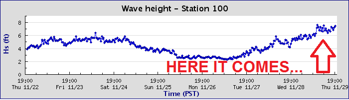
Wow. Winter hit 3 weeks early today. Gusty 30 mph+ winds, over an inch of rain, and 10' storm surf. Love it! If you've read THE Surf Report over the years, you know I'm not a big fan of boring fog- either it has to be sunny beach weather or batten down the hatches. Looks like I got my wish today with the latter. As far as the surf goes, we haven't had a 'real' rain in about 8 months so the water is REALLY dirty unfortunately and it's probably best to stay out until at least Sunday evening if you dare- or Monday. Not that it's going to be good anyway.

Currently Point Conception is 20' tonight and down here tomorrow we'll see 10'+ surf from the WNW and strong NW winds. Saturday has sunny skies in the AM and smaller surf but another cold front will sleep through late in the day and early Sunday. Behind that front will be more head high+ WNW windy surf. Not worth getting sick over. Water temps are still mid-60's and tides the next few days are around 4' at breakfast and down to 1' mid-day and up again to 4' at sunset.
FORECAST:
Early in the workweek starts off slow with only waist high WNW/SW and clean conditions.

But forecast models show a good storm taking shape this weekend that should give us head high WNW starting late Wednesday and lasting into Thursday morning. On it's heels is slightly bigger storm on the charts early next week which could give us well overhead WNW again next Saturday. All the while, storms next week (see below) may impact the quality of the surf. Plan accordingly.
WEATHER:

Nothin' like a good ol' fashion storm to kick off our rainy season. Most spots along the coast received 1" while the mountains between here and LA received 2-3". Wind was also a factor with this storm as peak gusts along the coast were 40 mph and the mountains had gusts of 70 mph. With the 1/2" of rain we received earlier this month, spots in Southern California now sit between 1.5-2"; which is 100% of normal. Glad to see us on track for once. As mentioned above, we have another weak cold front coming through mid-day on Saturday for maybe 1/4" or rain. Sunday will be cool and breezy while Monday/Tuesday will have sunny skies. Charts show another storm headed our way for Wednesday which may actually take aim at northern Baja so we could only get a glancing blow and 1/2" of rain. But that could all change between now and then. So make sure to keep track of the waves and weather at Twitter/North County Surf.
BEST BET:
Tough call since all of our swells are accompanied by stormy conditions. But if you must paddle out, try Monday morning with a quickly dying WNW. Or late next Wednesday with new WNW swell and hopefully rain holding off until Thursday!
NEWS OF THE WEEK:

What the heck is with wild weather happening on November 29th?! If you thought today's weather was interesting, check out what else happened on this date in history...
2006: Offshore winds gusted to 73 mph at Fremont Canyon (sustained 54 mph) and 58 mph at Ontario. Widespread property damage and power outages resulted from downed power lines, poles, and trees.
1997: A pocket of dense fog developed along Interstate 15 near Elsinore. In the span of 45 minutes, seven accidents involving 23 vehicles occurred along a half-mile stretch of the highway, which was closed for five hours.
1991: An intense winter storm swept into the region with strong winds and snowfall. Winds knocked out power to around 60,000 people in L.A. and San Diego. A 62 mph wind gust was reported in the San Fernando Valley. One woman was killed and 3 others were injured in a dust storm related traffic accident. Two hikers were trapped by snowfall on Mt. Baldy for 43 hours, where they survived estimated wind chills as lows as -35⁰F.
1976: It was 32° in Borrego Springs, the earliest date in the season to record a freezing temperature
1975: The first winter storm of season was a heavy one. It started on 11/28 and ended on this day. Up to two feet of snow fell in the San Bernardino Mountains, including 16 inches at Big Bear Lake. Twenty stranded campers were rescued after a few days. It was 17° at Palomar Mountain, the lowest temperature on record for November. This also occurred on 11/16/1964 and 11/16/1958. A 7.2 magnitude earthquake hit Hawaii on this day, sending a tsunami that hit Santa Catalina Island. In San Diego a 2.4-foot maximum amplitude was measured. Some damage resulted.
1970: A series of storms struck the region from 11/25 to 11/30 following large destructive wildfires in the San Bernardino and San Gabriel Mountains earlier in the fall. 9.17 inches of precipitation fell in Lake Arrowhead, 7.22 inches in Lytle Creek, 5.11 inches in Big Bear Lake, 5.02 inches in Palomar Mountain, 3.56 inches in San Bernardino, 2.63 inches in Redlands, 2.51 inches in Santa Ana, and 2.05 inches in San Diego. Flooding inundated streets and highways in the Rancho Cucamonga area. At least 60 homes were damaged by floods and debris flows.
PIC OF THE WEEK:

As you know, the Hawaiian's measure the size of a wave from it's back. So if you hear it's 4-6' 'Hawaiian', it's really 8-12' for us mortals. On that note, how big would the Hawaiians say this wave was since it doesn't have a back? I guess it was flat out there that day?
Keep Surfing,
Michael W. Glenn
Pioneer
Totally Over Social Media. Going To Start Communicating To My Fans Via Mental Telepathy
2014 World Skimboarding/Bodysurfing/