
Welcome summer!
SURF:

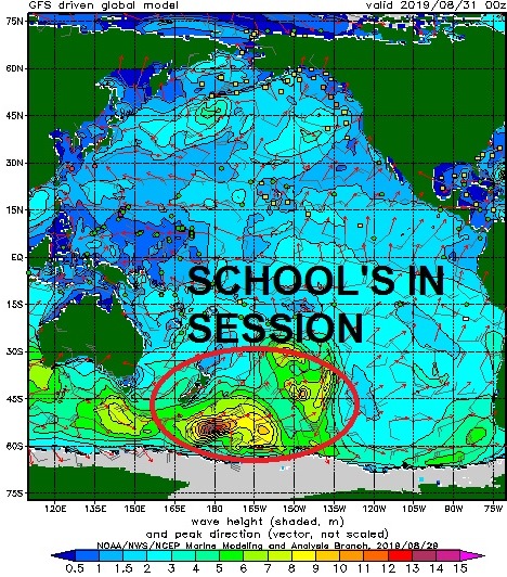

Not much surf to start the week but things started to look better yesterday as SW groundswell, S swell from Hurricane Juliette, and NW groundswell filled in. Along with water temps in the 75-79 degree range, warm humid weather, sunny skies, and tropical clouds overhead, summer has finally arrived- 2 weeks before fall! Better late than never. Look for chest high surf today with shoulder high sets in the OC. Julliette and the SW groundswell hold on Saturday (along with a continuation of the NW) and we'll have fun surf through Sunday morning. Long story short- skip your kid's soccer game, forget about mowing the lawn, and GET OUT THERE!
And here's more numbers to crunch:

Tides this weekend are pretty mellow:
- 4' at sunrise
- 2.5' at lunch
- 5.5' at dinner
- 6:27 AM sunrise
- 7:06 PM sunset

On the heels of Julliette and the SW over the weekend, we get reinforcing SW swell on Monday/Tuesday for chest high+ surf again. Models from last week had this as a pretty big storm but alas it backed off. No complaints though- fun high surf is better than no surf. After that, the Pacific takes a nap and the 2nd half of next week looks a little boring. If anything changes between now and then though (I'm talking to you hurricanes), make sure to check out Twitter/North County Surf.
WEATHER:

WEATHER:
Awesome weather this week (if you're into that sort of thing). Sunny skies, warm humid conditions, and yes- that was rain falling from the sky in south San Diego County on Wednesday. Weak cold fronts to our north start knocking on the door the next few days and as they do, air temps will start to drop slightly and more low clouds in the AM/PM will take hold. Still great beach weather by mid-day this weekend and temps in the high 70's. By mid-week were back to the mid 70's and more low clouds/fog.
BEST BET:
Saturday/Sunday with good combo swell, warm water, and sunny skies. What else do you want?
NEWS OF THE WEEK:
NEWS OF THE WEEK:

Another ridiculous day of water temperatures here in North County. All week we've been between 75-79 degrees. Big deal you say? You say last summer was over 80 degrees at Scripps Pier! True, but that was an oddity AND it was in August- the expected peak of water temps for summer. Or it used to be it seems. “Southern California coastal waters have been anomalously warm since the beginning of 2014, when we experienced a marine heat wave,” Daniel Rudnick, a Scripps oceanographer, said during last year's well above average sea surface temperatures. That event was popularly known as ‘the blob.’ The following year, during 2015-16, we had one of the strongest El Niños of the the last few decades and the local ocean continued warming.
“Since then, SoCal waters are still anomalously warm — that is, the water has not returned to temperatures that were normal in the previous seven years,’’ Rudnick said. Global warming to blame? Just a normal oceanic cycle (we've only been keeping accurate records since 1916 so it could be)? Whatever it is, it doesn't seems to be the norm for the immediate future.

Our warmest water temperatures of the year usually occur at the beginning of August (like last year's 80 degree readings at Scripps). This year we had a pretty mild summer when it came to water temps but this week's heatwave and lack of upwelling from NW winds helped flip the switch and we're up to the high 70's- which never happens in September- as ocean water temperatures should be on their way down and headed towards winter by now.

So before 2014, just what are 'normal' water temperatures? Here's a snapshot of Scripps Pier:
- January = 58 degrees
- February = 57 degrees (coldest water temps of the year)
- March = 58 degrees
- April = 60 degrees
- May = 63 degrees
- June = 65 degrees
- July = 67 degrees
- August = 68 degrees (warmest temps of the year)
- September = 66 degrees
- October = 63 degrees
- November = 61 degrees
- December = 59 degrees
As you can see above, we're about 12 degrees warmer than we should be for September. But is anyone complaining? (Besides the environment being all out of whack that is).
PIC OF THE WEEK:

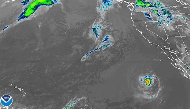
Keep your positive thoughts for the Outer Banks today as they've getting a lashing from Hurricane Dorian. Hope that once the dust settles, they'll see some of this.
Keep Surfing,
Keep Surfing,
Michael W. Glenn
Supreme
Hoping Hurricane Dorian Doesn't Hit Alabama Too
Need To Call Corkys Carroll To Remove The Pests In the Lineup