Back from sabbatical.
SURF:
Decided to take some time off last month and find myself. And I found out I was... a surfer. So let's get to it!
As you probably realized, during the past two weeks I forgot to turn off the Emergency Boardriding System, but I don't think anyone is complaining. Lots of solid surf has left the weak waves of 2020 in our rearview mirror.
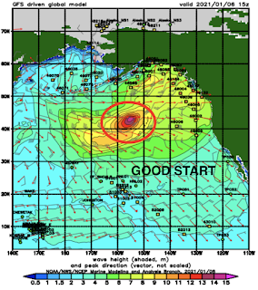
For Friday, we have yet ANOTHER WNW swell filling in for overhead surf and 10' sets at best spots in SD. That holds into Saturday and picks up a notch on Sunday afternoon for well overhead surf here in North County and double overhead sets at good SD spots. So we have that going for us. And here's the tides, sun, and water info:
- Sunrise and sunset:
- 6:52 AM sunrise
- And the sun finally sets at 5 PM!
- AND... in case you're wondering, you probably won't be able to surf after work (if anyone works 9-5 anymore) until probably late February as the sun will be setting around 5:45 PM by then and 6:56 PM due to Daylight Savings Time on March 14th.
- And if you haven't surfed since September, you're in for a rude awakening as water temps are 58 at best.
- And tides this weekend will make picking your spot a bit tricky with the big surf:
- 6' at sunrise
- -1' after lunch
- 2' at sunset
FORECAST:
Make sure to pace yourself this weekend as Monday is going to wallop you upside the head. As the surf continues to pick up on Sunday, it will peak on Monday with 10' sets in North County San Diego and double overhead+ sets in SD. We finally get to ride those step ups again! Tuesday starts to back off to the overhead range and Wednesday is finally manageable.
Charts then show a more modest WNW taking shape this weekend which would give us head high to overhead surf again next weekend. We also have some small storms off Antarctica that is sending waist high surf our way (and better in the OC) but it will be steamrolled by the WNW swells. Maybe the OC will have better luck seeing these SW swells later next week. And the icing on the cake this weekend? Slight high pressure is building for weak offshore flow and sunny skies. No more of this pesky fog thank goodness. Make sure to check out Twitter/North County Surf if anything changes between now and then.
BEST BET:
This weekend if you like good surf. Or Monday if you like to have your heart race as you dodge a few sets.
WEATHER:
Good to see some rain and snow between Xmas and New Year. Hope you enjoyed it because La Nina is in full effect and California is bone dry in the middle of our rainy season. But let's stay positive- the high pressure setting up this weekend will give us great weather- temps in the high 60's, light offshore winds, and plenty of sun. Throw in some solid surf and you've got Grade A conditions here in San Diego County. Shhhhh- don't tell your friends up north. Nice conditions and light offshore winds persist into most of next week with no long range models showing rain anytime soon.
NEWS OF THE WEEK:
NEWS OF THE WEEK:
As you may or may not know, I studied Meteorology in college with the goal of becoming a weather forecaster. My hero was Pat Sajak, a weather forecaster in L.A. who eventually became a highly paid game show host (which is the ultimate gig; work a couple hours a day, make people laugh, and pull in $15 million a year. And no, that's not a typo). I also studied Geology because ocean swells are useless unless they have something to break on.
On that note, one thing that always intrigued me was the geology of California. In particular 3 areas:
- The San Francisco Bay and how it flooded the San Joaquin Valley about 66 million years ago during the early Paleocene era. Broad fluctuations in the sea level caused various areas of the valley to be flooded with ocean water for the next 60 million years. About 5 million years ago, the marine outlets began to close due to uplift of the coastal ranges and the deposition of sediment in the valley.
- How the highest point in the continental United States- Mt. Whitney at 14,505'- affected the weather below it at arguably the hottest place on earth- Death Valley. The answer is the rain shadow effect: When clouds hit a high geographic feature- like a mountain- the rain gets squeezed out the and the land on the opposite side- bone dry. In this case- Death Valley.
- And the last question I had; did the waters of the Gulf of California ever creep up towards the Coachella Valley- right behind us here in Southern California? The answer....
Layers of sedimentary rocks bearing marine fossils, burrows and diagnostic sedimentary structures, the researchers concluded, record a dramatic rise in sea level that drowned former alluvial fans and caused tidal waters to invade the valley prior to arrival of the Colorado River and its voluminous load of water and sediment. The studies, both funded by the National Science Foundation, were published online ahead of print in the international journal Sedimentology.
The first paper focused on sediments of the late Miocene to early Pliocene Bouse Formation exposed east of the Colorado River, south of Blythe, California. Previously, O'Connell and a team of UO geologists had found evidence that the Gulf of California once reached as far north as Blythe, as detailed in the journal Geology in 2017.
In the new paper, O'Connell and co-authors describe a rich mixture of carbonate mudstones, plant debris and traces of ancient organisms that record brackish water conditions where seawater was diluted by a large influx of fresh water due to high annual rainfall, before waters of the Colorado River flowed into the area. The sediments, they found, formed in wide tidal flats along an ancient, humid-climate marine shoreline. An abrupt transition to low-energy subtidal lime mudstone records widespread marine flooding associated with a long-lived regional rise in sea level, they concluded. Relative sea level rise, they added, resulted from long-term tectonically controlled subsidence. The combined evidence from paleontology, ichnology and process sedimentology "provides a clear record of freshwater input and brackish water conditions due to mixing of freshwater and seawater in a humid climate with high annual precipitation," O'Connell's team wrote.
The second paper, published Dec. 5 and led by Gardner, documents tidal sediments of the same age on the opposite side of the same ancient tidal strait. The sediments accumulated where strong daily reversing currents swept north and south along the axis of the tidal strait, driving migration of large subtidal dunes and depositing large scale cross-bedded carbonate sands.
The authors argue that the migrating dune bedforms could not have formed by tidal like processes in a lake, as some scientists have proposed. The team's results indicate that, after late Miocene to early Pliocene deposition, the sediments were uplifted to elevations up to 330 meters above sea level in the Chocolate Mountains, as a result of long-term crustal strain related to motion on the San Andreas fault. "Taken together, our new papers provide conclusive evidence that the southern Bouse Formation formed in and around the margins of a marine tidal strait that filled the lower Colorado River valley prior to arrival of the modern river system," said Dorsey, a professor in the UO's Department of Earth Sciences.
A map of the southern Bouse tidal seaway, reconstructed with data from both studies, shows that desert communities from Blythe to Palo Verde, California, were submerged under shallow seas with strong fluctuating tidal currents during late Miocene to early Pliocene time.
The Miocene, a geological epoch, lasted from 23 million years ago to 5.3 million years ago; the Pliocene occurred between 5.3 million and 2.6 million years ago. In 2018, another Dorsey-led paper in the journal Sedimentary Geology found that lower stretches of the Colorado River were influenced by tectonic shifts in underlying bedrock and changing sea levels. The river, that study concluded, experienced a series of stops and starts in sediment output during early stages of the river between roughly 6.3 and 4.8 million years ago.
PIC OF THE WEEK:
A good 6/5/4, hood, booties, gloves, and a fire on the beach, I'm there!
Keep Surfing,
Michael W. Glenn
Superior
Can't Wait For 2022!
Getting A 2nd Opinion About Turning Pro


