All the flavor and without the calories.
SURF:
Been a great winter so far- heaps of surf and no stormy conditions. You know winter has to arrive sooner or later, don't you?
I mean, we're 4 weeks into the season and it's been sunny, warm, and a few offshore days thrown in. If the water wasn't 58, I'd say it was September around here. But I'll talk about the big changes in store for us later. Here's what's going on the near term:
For Friday it looks to be just small waist high SW from an early season storm in the southern Hemisphere.
That is joined by a much needed cold front late in the day for a chance of showers finally. Look for Saturday to be a bit bumpy as the front exits the region but it will bring short period NW windswell for chest high+ surf. Sunday looks to be clean with more chest high+ NW. All in all, Sunday morning looks best- if the rains from Friday night didn't pollute the ocean. Here's the tide, sun, and water temps to plan your session accordingly:
- Sunrise and sunset:
- 6:48 AM sunrise (paddle out by 6:30 AM!)
- 5:13 PM (paddle in by 5:30 PM!)
- Water temps are in the high 50's.
- And nothing exciting in the tide department this weekend:
- 4' at sunrise
- 0.5' at lunch
- 3' at sunset
FORECAST:
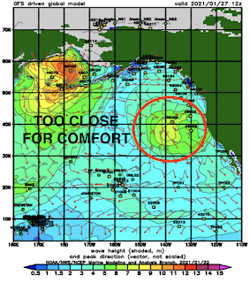
This weekend will literally be the calm before the storm. Charts finally show high pressure getting out of the way and storms taking aim at California next week. Which should be the case for January.
Monday a cold front muscles it's way into Southern California and will unleash rain, wind, and potentially 12' stormsurf. Tuesday the storm should exit but expect breezy NW winds and more out of control surf.
After that, models are having trouble nailing down the next storm but my guess is that at least Wednesday will be cleaner and manageable (but dirty water) and the next potentially larger storm arrives late next week for more rain and big stormsurf. Make sure to check out Twitter/North County Surf if anything changes between now and then.
BEST BET:
Tough call: Friday will be small but clean conditions and water. Sunday will have better surf but suspect water. And next week may have a bigger surf but bumpy conditions and definitely dirty water.
WEATHER:
As mentioned above, it looks like we'll have rain finally. And not a moment too soon with a couple of brush fires here in SD the past week. Looks like we have a small cold front coming through Friday evening for around 1/4"-1/2" along the coast and 2-4" of snow in the mountains. Saturday afternoon should be cool, mostly sunny, and breezy. Sunday is a nice day before the next cold front arrives late. This one looks like a real winter storm on Monday with potentially 1" of rain, lots of NW wind, and heaps of stormsurf. After that, charts show a robust storm off the Northern CA coast next Wednesday which could wallop us late next week for more rain, wind, and stormsurf. If you haven't already, get those gutters cleaned, bring in the patio furniture, and patch those holes in the roof!
NEWS OF THE WEEK:
NEWS OF THE WEEK:
Since you're an extreme athlete (does the media even say that anymore about surfers, skaters, snowboarders, BMXers, and MXers?), then you're probably enjoying this extreme winter. Case in point:
- A unique situation this week had high pressure in the interior West and low pressure below us in Baja. Those two acted like gears and squeezed out:
- 80-90 mph winds in the San Diego County Mountains yesterday
- 1" of rain in the San Diego County Mountains too
- The Sierras had wind gusts over 100 mph on Tuesday
- Multiple high temperatures were broken last Friday the 15th in San Diego county:
- Vista at 94
- Escondido at 91
- San Diego at 88
- And we received no rain for almost 2 months- from early November to late December
But enough of the heat, offshore winds, and dry conditions. We look to be headed towards a wet period for at least the next 7 days. Let's take a look at where we stand today for rainfall:
- Newport Beach: 1.44" so far but we should be at 6.33". Only 23% of normal!
- Oceanside: 1.47" so far but we should be at 5.88". Only 25% of normal!
- San Diego: 0.98" so far but we should be at 4.40". Only 22% of normal!
Let's hope Friday's storm drops 1/2", Monday's storm 1" and the potential storm later next week at least another 1". That would add roughly 2-2.5" to our totals. At that point, most rain gauges would be at 3.5"-4"- and still only 65% of normal. Don't look a gift horse in the mouth?...
PIC OF THE WEEK:
Is this Swamis, Bells, or Ribeira? Let's do the math: Swamis in Encinitas and Bells in Victoria, Australia probably saw their first surfers in the 1930's and most likely crowds by the 50's. Ribeira, Portugal on the other hand most likely didn't see surfers until US troops settled after World War II (mid to late 1940's) and the surf industry took hold in Europe in the 80's. So that gives Swamis and Bells a few decades head start in the crowd department. My guess where this empty line up is? Riberia. (Plus, I already know the answer so that's cheating).
Keep Surfing,
Michael W. Glenn
Adept
On The Cover Of The Tabloids Again
Just Realized I've Been Surfing The Wrong Way This Whole Time


