
2022 Is Lookin' Up!
SURF:

Hope Santa didn't bring you a surfboard for Christmas 'cause you've probably had a hard time finding waves to ride it on. But fear not! 2022 is looking up! But we have to get through 2021 first.

On that note, we've got some leftover waist high sets from SW/NW windswells for Friday but may see a little more NW groundswell late in the day and into Saturday morning for chest high sets towards SD. For Sunday- not so much. And here's the tides, sun, and water temps for the next few days:
- Sunrise and sunset:
- 6:51 AM sunrise
- 4:54 PM sunset
- and just like that- the days are getting longer
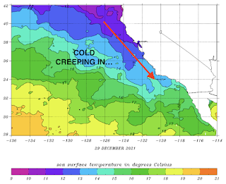
- Water temps are feeling like winter (because it is) clocking in at a chilly 58 degrees

- And the most exciting thing this weekend?... THE TIDES! Check these babies out:
- a HUGE 7' high tide around 7:30 AM
- DROPPING ALMOST 9' to a -2' around 3 PM. That's over 1' an hour!
- and back up slightly to 0' at sunset
FORECAST:

As mentioned in last week's THE Surf Report, high pressure has basically been above Hawaii the past month so storms that try to form off Japan get pushed into Alaska/British Columbia instead of roaring through Hawaii and aimed at California. With that being said, let's talk about next week.

Looks like one last storm will form off British Columbia and a steep angled NW will fill in Wednesday for chest high sets towards SD.
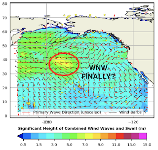
Behind that, we could see a real WNW groundswell for chest high surf around the 9th with shoulder high waves in SD.

And after that, models show a slightly better WNW towards the 11th for shoulder high waves in N County SD and head high in SD. Keep your fingers crossed that we're finally on track to see some groundswells around here- and rideable waves for winter 2022.
WEATHER:

Did you enjoy the rain? Good, 'cause it looks like it's done for the near future. If recent history is any indication- wet October, dry November, wet December- we'll go dry for the month of January. In the short term, look for cool sunny skies most of next week with temps in the low 60's. If anything changes between now and then, make sure to follow North County Surf on Twitter!
BEST BET:
Late Friday/early Saturday and Wednesday small NW groundswell. Or hold your horses until the 9th and 11th with fun WNW groundswell finally.
NEWS OF THE WEEK:

Based on the past week's downpours, how did we do to help our drought situation? Here's the latest:
- Newport Beach:
- 2.37" before Xmas (92% of normal)
- 3.21" of rain the past week
- new total of 5.58" (169% of normal)
- Oceanside:
- 3.08" before Xmas (108% of normal)
- 2.19" of rain the past week
- new total of 5.27" (158% of normal)
- San Diego:
- 2.11" before Xmas (93% of normal)
- 1.48" of rain the past week
- new total of 3.59" (124% of normal)

As mentioned above, it wouldn't surprise me if we went somewhat dry in January as our weather lately has been all or nothing. But the good news is, January is typically our 2nd wettest month for San Diego- so even less than normal rainfall should wring out a few showers here and there. And in case you're wondering, here's our typical rainfall for SD based on average totals:
- February 2.25"
- January 2"
- March 1.75"
- December 1.5"
- November 1"
- April 0.75"
- October 0.5"
- September 0.25"
- May 0.25"
- June 0.1"
- July < 0.1"
- August < 0.1"
As you can see above, at least we have January, February, March, and April rainfall to potentially look forward to.
PIC OF THE WEEK:

This treacherous right barrel in Canada is named Drake's Point. Popular to contrary belief though, it is not named after English explorer Sir Francis Drake, but rather Toronto's gift to modern music, Aubrey Graham. (Nice, for what)?!
Keep Surfing,
Michael W. Glenn
Prominent
Could Do This In My Sleep
Haven't Missed A Day Of Surfing In 37 Years
Michael W. Glenn
Prominent
Could Do This In My Sleep
Haven't Missed A Day Of Surfing In 37 Years