And we're back to normal.
SURF:
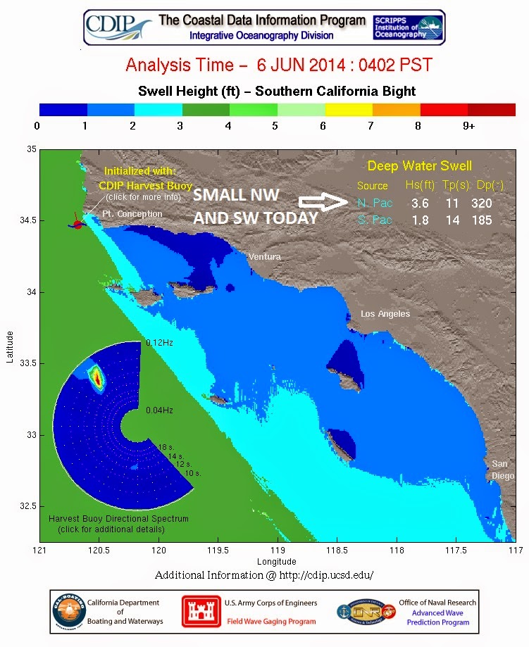
Mighty fun surf the past few days with good SW groundswell being joined by good NW windswell (and if you were in the OC you got a taste of our upcoming hurricane summer with fun SE Amanda swell).
Today all swells are winding down but there's still chest high waves in north county SD and head high sets in the OC. Unfortunately there's not much on tap for the weekend except some background SW/NW swells. Best combo spots will pull in chest high waves.
Water temps have been fluctuating between 68 and 70 the past few days (just depends how early the clouds burn off each day) and tides are -1' at sunrise, up to 4' at lunch, down to 2' late afternoon, and back up to 4' again at sunset. Make sure to keep up to date on the waves/weather at
Twitter/North County Surf. FORECAST:
Southern and northern hemispheres have been pretty quiet recently so there's no big swells headed our way for the near future.
We did have a little storm flare up under New Zealand a few days ago but it wasn't big and it was stuck behind the south Pacific islands. We should get some inconsistent chest high waves around the 3rd of June with maybe a bigger set in the OC. Models are showing winds of central CA being pretty consistent the next few days so we should have some waist high NW windswell for the foreseeable future.
Forecast charts have a storm forming in the southern hemisphere in a few days and if everything holds up we may get a good SW around the 8th of June. But until then- put the step up away.
On the hurricane front, we have another area of disturbed weather off mainland Mexico trying to get organized. Still a LOOOONG way off from forming into a hurricane but it bares watching.
WEATHER:
Forecast models a few days ago had this weekend looking pretty gray and dismal. Thankfully they've backed off their dire predictions and it now looks to be pretty seasonal around here- just night and morning low clouds and mostly sunny afternoons. Nothing baking but nice beach weather with temps around 70. Clouds may thicken the 2nd half of next week but nothing out of the ordinary for an expected June Gloom.
BEST BET:
Nothing stellar but maybe today with leftover SW/NW or maybe next Tuesday with a small pulse of new SW and background NW OR... maybe late next weekend with building SW.
NEWS OF THE WEEK:
With all the wild weather lately (100 degree temps at the beach, strongest hurricane on record for May), I thought a review was in order on the state of Mother Nature for the month of April. Here’s how she’s been holding up:
Global Highlights•The combined average temperature over global land and ocean surfaces for April 2014 tied with 2010 as the highest on record for the month, at 0.77°C (1.39°F) above the 20th century average of 13.7°C (56.7°F).
•The global land surface temperature was 1.35°C (2.43°F) above the 20th century average of 8.1°C (46.5°F), marking the third warmest April on record. For the ocean, the April global sea surface temperature was 0.55°C (0.99°F) above the 20th century average of 16.0°C (60.9°F), also the third highest for April on record.
•The combined global land and ocean average surface temperature for the January–April period (year-to-date) was 0.64°C (1.15°F) above the 20th century average of 12.6°C (54.8°F), the sixth warmest such period on record.
AprilThe globally-averaged temperature across land and ocean surfaces tied with 2010 as the highest on record for the month, at 0.77°C (1.39°F) higher than the 20th century average. This also ties with April 2010 as the seventh highest departure from average among all months in the period of record, which dates back to January 1880. The record highest departure is 0.86°C (1.55°F) above average, set in February 1998, a month when El Niño conditions had been present for nearly a year. Neither El Niño nor La Niña have been present in the east central equatorial Pacific Ocean for the past two years; however, according to NOAA's Climate Prediction Center, the chance of El Niño emerging increases for the remainder of 2014, exceeding 65 percent during the Northern Hemisphere summer 2014.
In the Northern Hemisphere, the combined temperature over land and ocean surfaces tied with 2012 for record April warmth. Land surfaces here were 1.54°C (2.77°F) higher than the 20th century average. Part of the warmth can be attributed to record warmth in much of central Siberia, where temperatures across a large region were at least 5°C (9°F) above the 1981–2010 average for the month. Overall, more than half of the Eurasian continent, along with northern Africa and most of Mexico, were much warmer than average, as indicated by the Land & Ocean Percentiles map above. Only parts of central and eastern North America were cooler than average for the month in this hemisphere.
The Southern Hemisphere was fourth warmest across land and ocean surfaces combined. Land surfaces were ninth warmest for April, at 0.82°C (1.48°F) above average. Regions of eastern Australia and part of western Indonesia were record warm. Only part of southern South America was cooler than average in this hemisphere.
•Although the global temperature tied for record highest, the contiguous U.S. observed only its 46th warmest April and much of Canada had cooler-than-average to near-average temperatures for the month. This contrast is an example of how a globally-averaged temperature can differ from a single smaller region.
•Australia observed its seventh highest average April temperature since records began in 1910, at 1.12°C (2.02°F) higher than the 1961–90 average. The average minimum temperature was fourth highest for April, at 1.32°C (2.38°F) above average, with Queensland setting a new record high monthly minimum for the state.
•It was the third warmest April since records began in 1910 for the United Kingdom, at 1.8°C (3.2°F) above the 1981–2010 average. April also marked the fifth month in a row of above-average temperatures for the UK.
The globally-averaged ocean temperature was the third highest for April, at 0.55°C (0.99°F) higher than the 20th century average. Continuing its recent trend, part of the eastern North Pacific Ocean was record warm. Several other regions were also record warm, including parts of the eastern equatorial Pacific off the coast of Mexico and scattered regions of the equatorial western and South Pacific, western North and South Atlantic Ocean, sections of the Norwegian and Berents Seas, the central Indian Ocean, and regions of the Southern Ocean south of Africa. Regions of the central North Atlantic, eastern South Pacific and a small section of the western central Pacific, and the Southern Ocean south of South America were much cooler than average for April.
The average temperature across global land and ocean surfaces for the first four months (January–April) of 2014 was the sixth highest for this period on record. The warmth was relatively evenly distributed between the Northern and Southern Hemispheres, with each also observing their sixth warmest January–April on record (the Southern Hemisphere tied with 2004).
The average land surface temperature across the Northern Hemisphere was the eighth highest in the 135-year period of record, with record warmth for the year-to-date observed in parts of the western United States, regions of northern and southern Europe into northern Africa, parts of Far East Russia, and coastal western Alaska. The average temperature across Southern Hemisphere land areas was the 10th highest on average for January–April. In this hemisphere, most of Australia and eastern and northwestern South America were much warmer than average, with part of eastern Brazil observing record warmth, as indicated by the Land & Ocean Temperature Percentiles map.
The globally-averaged ocean temperature for January–April was the third highest on record for the period, due in part to record warmth in parts of each of the major ocean basins, particularly notable in the northeastern Pacific Ocean, regions of the western North and South Atlantic, and the ocean waters south of South Africa.
Some major storm systems brought heavy rainfall to isolated areas:•Severe Tropical Cyclone Ita made landfall in Queensland Australia north of Cooktown on April 11th. According to satellite data, rain was falling at a rate of 91 mm (3.6 inches) per hour near the center of the storm as it approached land. The storm also severely impacted the Solomon Islands, along with Papua New Guinea and nearby islands.
•On April 29th and 30th, torrential rain fell across the Southeast, Mid-Atlantic, and Northeastern United States. In Pensacola, Florida, the 2-day precipitation total was 520 mm (20.47 inches). With 395 mm (15.55) inches of the total falling on the 29th, this marked the all-time wettest calendar day in Pensacola since records began in 1880, breaking the previous record of 388 mm (15.29 inches), recorded on October 5th 1934 when an unnamed tropical storm impacted the area
BEST OF THE BLOG:
Summer's coming and it's time for a new groveler. Too many choices out there? Or maybe you don't want to wait for a custom stick? Well, take manners into your own hands and shape your own! The Shaper Studios can help with that. Make sure to check out the story on the North County Surf blog. As well as a mid-week Surf Check and an in-depth THE Surf Report. All of that and more in the blog below!
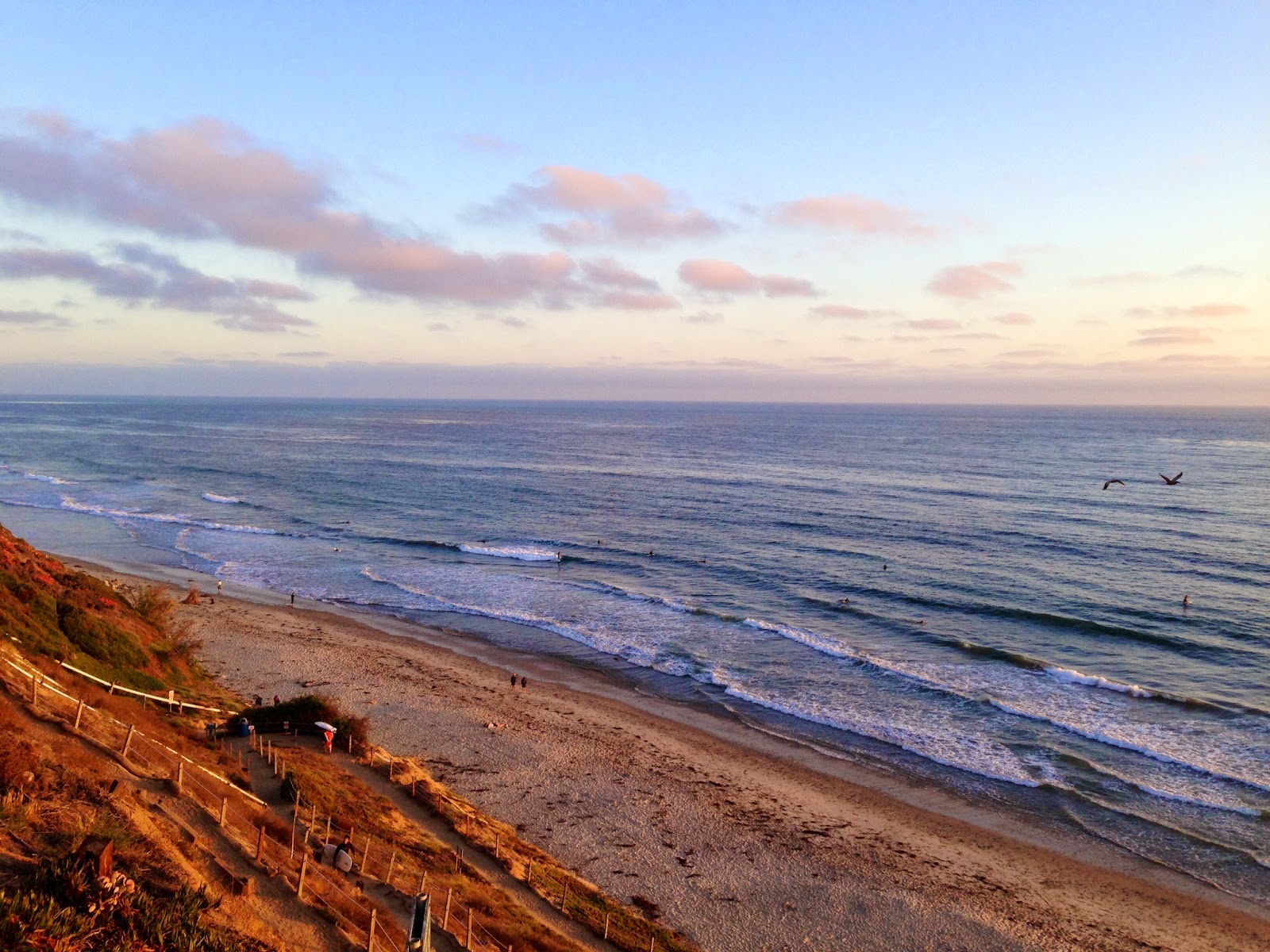
PIC OF THE WEEK:
Remember that old black and white drawing in which you can see either a young lady or an elderly hag- just depends on your point of view? Well, here's the surf world's version. A barrel to get you stoked off your mind- but ominous clouds in the background. Or the heavens shining above- but one disgusting slab you want no part of. What do you see?
Keep Surfing,
Michael W. Glenn
Soothsayer
Cried At Kimye’s Wedding
Cooler Than The Coolie Kids