Is Ol’ Man Winter finally knocking at the door?
SURF:
Not much in the way of surf this past week. Just a little bump from the NW on Monday but the W winds blew it to bits in the afternoon. If you got a morning session in, you were lucky. Nothing much the past few days and today we’ve got a little bump up from the NW and SW.
Some waist high waves around town and inconsistent chest high. There’s a little S wind headed our way this evening too. Good news is that we’ve got solid NW coming this weekend- bad news is that we have some weather associated with it too (more on that in the WEATHER section below). Saturday starts off slow in the surf department with chest high+ surf and there’s some rain and 15mph+ SW wind during the day. Sunday looks to be sunnier with overhead surf- but with the storm exiting the region we may have junky WNW winds in the morning. In a nutshell- we’ve got rain on Saturday and surf on Sunday. Water temps are still a chilly 57 degrees.
Tides are all over the place this weekend; 6.5’ at dawn, -1.5’ at 2pm, and back up slightly to 2’ at sunset. Make sure to keep up to date on the waves and weather at Twitter/North County Surf.
FORECAST:
After the storm exits the region with junky surf on Sunday, we’ve got a small storm lined up for Monday and the surf drops slightly to the head high range for north county SD/OC, overhead still in south SD, and some chest high waves in south OC. On Tuesday we have yet another solid swell and clearing conditions with WNW winds and overhead NW surf. By Wednesday things are back to normal with clear cool skies and dropping NW. Thursday looks to be about waist to chest high and charts show some fun NW for next weekend. Should be a good week for surf if you don’t mind the cold fronts at the beginning of the week.
Charts also show some activity in the southern hemisphere next week- best chast scenario is to get some chest high+ surf towards the first week of February here.
WEATHER:
Charts earlier in the week showed a solid winter storm headed our way this weekend but have now backed off on that scenario. I was hoping for some 25mph S winds and 1” of rain- but alas it looks like we’re left with ¼” of rain on Saturday and 15mph S winds. Sunday we’ve got a cool breezy sunny day on tap as the storm exits the region and WNW winds about 10mph in the morning. On Monday we’re due for another small storm- even less impressive than Saturday’s- with rain about 1/10th of an inch and S winds around 10mph+. By the middle of the week we should be left with sunny skies and warm temps in the low 70’s. Just a little taste of winter in the coming days but nothing full blown.
BEST BET:
Hard to say- we’ve got solid overhead surf on Sunday and Tuesday but two associated cold fronts will be exiting the region those days so we may have junky WNW winds making a mess of the surf. Personally, I like storm surf- lot’s of peaky surf and no one out. But if you like clean manageable conditions- you may want to wait until Wednesday.
NEWS OF THE WEEK:
The National Oceanic and Atmospheric Administration has a wealth of knowledge about the oceans. More Jeopardy trivia than you can shake a stick at! Anyway, enough politics. Here’s some facts about the ocean from their website. http://www.noaa.gov/
-Difference between a storm surge and a tidal wave? A storm surge is the water that is pushed toward the shoreline by the force of winds from a hurricane or other intense storm. When combined with normal tides, the surge can create water levels 15 feet or more about the mean water level. This rise in water can cause severe flooding in coastal areas. A tidal wave is a shallow water wave caused by the gravitational interactions between the Sun, Moon, and Earth. The term “tidal wave” is often used to refer to tsunamis; however, this reference is incorrect as tsunamis have nothing to do with tides.
-What is a rip current? Rip currents are powerful, narrow channels of fast-moving water that are prevalent along the East, Gulf, and West coasts of the U.S., as well as along the shores of the Great Lakes. Moving at speeds of up to eight feet per second, rip currents can move faster than an Olympic swimmer. Panicked swimmers often try to counter a rip current by swimming straight back to shore—putting themselves at risk of drowning because of fatigue. Lifeguards rescue tens of thousands of people from rip currents in the U.S. every year, but it is estimated that 100 people are killed by rip currents annually. If caught in a rip current, don't fight it! Swim parallel to the shore and swim back to land at an angle. While the terms are ofter confused, rip currents are different than rip tides. A rip tide is a specific type of current associated with the swift movement of tidal water through inlets and the mouths of estuaries, embayments, and harbors.
-Where is the highest tide? The highest tides in the world can be found in Canada at the Bay of Fundy, which separates New Brunswick from Nova Scotia. At some times of the year the difference between high and low tide in this Bay is 16.3 meters (53.5 feet), taller than a three-story building. Anchorage, Alaska, comes in at a close second with tidal ranges up to 12.2 meters (40 feet). At increasing lattitudes (as one moves further from the equator and closer to the poles) there often is a dramatic increase in tidal range. Tidal highs and lows depend on a lot of different factors. The shape and geometry of a coastline play a major role, as do the locations of the Sun and Moon. Storm systems at sea and on land also shift large quantities of water around and affect the tides. Detailed forecasts are available for high and low tides in all sea ports, but are specific to local conditions.
-What is a Rogue wave? Rogue, freak, or killer waves have been part of marine folklore for centuries, but have only been accepted as a real phenomenon by scientists over the past few decades. Rogues, called 'extreme storm waves' by scientists, are those waves which are greater than twice the size of surrounding waves, are very unpredictable, and often come unexpectedly from directions other than prevailing wind and waves. Most reports of extreme storm waves say they look like "walls of water." They are often steep-sided with unusually deep troughs. Since these waves are uncommon, measurements and analysis of this phenomenom is extremely rare. Exactly how and when rogue waves form is still under investigation, but there are a couple known causes:
1. Constructive interference. Extreme waves often form because swells, while traveling across the ocean, do so at different speeds and directions. As these swells pass through one another, their crests, troughs, and lengths sometimes coincide and reinforce each other. This process can form unusually large, towering waves that quickly disappear. If the swells are travelling in the same direction, these mountainous waves may last for several minutes before subsiding.
2. Focusing of wave energy. When waves formed by a storm develop in a water current against the normal wave direction, an interaction can take place which results in a shortening of the wave frequency. This can cause the waves to dynamically join together, forming very big 'rogue' waves. The currents where these are sometimes seen are the Gulf Stream and Agulhas current. Extreme waves developed in this fashion tend to be longer lived.
BEST OF THE BLOG:
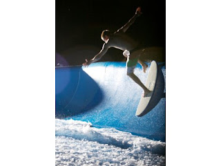
If you don’t have Dane Reynold’s website bookmarked by now- you should. Dane’s latest clip called ‘singles part 3’ is absolutely nuts. I challenge anyone to put together a better montage of footage in a shorter period of time. Shot around Ventura at the end of December/beginning of January- the surfing is beyond comprehensible. I weep for the past. Or if you even want something more futuristic, check out the new ‘half pipe’ wave pool they’re building in San Clemente. Seriously. And of course the mid-week Surf Check and a more in-depth THE Surf Report- all of that in the blow below!
PIC OF THE WEEK:
I love how there’s still lots of places out there with heaps of empty surf. Western Oz. Indonesia. Africa. And of course New Zealand. Friendly people. Friendly food. And friendly waves. I can’t afford a plane ticket down there- but when I win the lottery- I’m out there! I’ll send a postcard. For more amazing shots from the land of the Kiwi’s, check out AndrewShield’s portfolio.
Keep Surfing,
Michael W. Glenn
Hunk
Most Searched Name On The Internet
Making Beavertails Cool Again


