Welcome El Nino!
SURF:
Not to say I told you so, but, I told you so! No one believed in El Nino (just like Santa Claus) and he's finally here! Just 2 years after the fact and right in the middle of La Nina, but still! He's here! I think. I'm totally confused. Can't complain though; we need the rain to help with the drought (and keep my lawn green).
FORECAST:
Monday the surf is finally clean but small in the waist high range.
WEATHER:
Great start to our winter and we're only 1 day into it. We're sitting at roughly 3.5" or rain so far (about 125% of normal for this time of year) and we're about to get up to 1.5" more tomorrow through Saturday. Fill those resevoirs! Look for fairly clean weather in the AM tomorrow then the winds will pick up from the SSW all day.
BEST BET:
Early tomorrow with small building NW swell and clean conditions or next Tuesday with fun chest high NW and MAYBE clean conditions. Or... Thursday with chest high NW again and most likely clean conditions.
NEWS OF THE WEEK:
Sometimes I get so wrapped up in talking about waves that I forget to get down to basics and talk about what exactly makes the waves tick. Our good friends at the National Oceanic and Atmospheric Administration can break it down for us…
The ocean is never still. Whether observing from the beach or a boat, we expect to see waves on the horizon. Waves are created by energy passing through water, causing it to move in a circular motion. However, water does not actually travel in waves. Waves transmit energy, not water, across the ocean and if not obstructed by anything, they have the potential to travel across an entire ocean basin.
Waves are most commonly caused by wind. Wind-driven waves, or surface waves, are created by the friction between wind and surface water. As wind blows across the surface of the ocean or a lake, the continual disturbance creates a wave crest. These types of waves are found globally across the open ocean and along the coast.
More potentially hazardous waves can be caused by severe weather, like a hurricane. The strong winds and pressure from this type of severe storm causes storm surge, a series of long waves that are created far from shore in deeper water and intensify as they move closer to land. Other hazardous waves can be caused by underwater disturbances that displace large amounts of water quickly such as earthquakes, landslides, or volcanic eruptions. These very long waves are called tsunamis.
Out in the depths of the ocean, tsunami waves do not dramatically increase in height. But as the waves travel inland, they build up to higher and higher heights as the depth of the ocean decreases. The speed of tsunami waves depends on ocean depth rather than the distance from the source of the wave. Tsunami waves may travel as fast as jet planes over deep waters, only slowing down when reaching shallow waters. Storm surge and tsunamis are not the types of waves you imagine crashing down on the shore. These waves roll upon the shore like a massive sea level rise and can reach far distances inland.
The gravitational pull of the sun and moon on the earth also causes waves. These waves are tides or, in other words, tidal waves. It is a common misconception that a tidal wave is also a tsunami. The cause of tsunamis are not related to tide information at all but can occur in any tidal state. While tsunamis are often referred to as tidal waves, this name is discouraged by oceanographers because tides have little to do with these giant waves.
There are many other types of waves in our universe like sound waves, string waves, radio waves, visible light waves, microwaves, sine waves, stadium waves, earthquake waves, cosine waves, and slinky waves to name a few. But as surfers, we only care about water waves.
PIC OF THE WEEK:
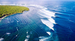
If you could only surf one wave the rest of your life, would you surf this left? Even it means you never saw another right the rest of your life?
Keep Surfing,
Michael W. Glenn
Never Been Better
Still Believe in Sandy Claws
Just Shaped a 10’0’ Yule Tide Log


