
At least the groms are stoked.
SURF:

Another small semi-clean week of surf. Had a little NW show
up Monday/Tuesday with a touch of early season SW for chest high sets- but that
was about it. Today there was leftover NW/SW for waist high waves. This afternoon
the NW wind was blowing and it didn’t do much to build up the surf. For
tomorrow, look for waist high+ NW/SW again with clean conditions. Saturday
drops slightly but it’s still waist high. Sunday the low clouds return and the
surf drops to knee to waist high. All in all some nice weather Friday/Saturday
and small waves but not enough to get the adrenaline flowing.

Water temps are
high 50’s and the tides this weekend are 3’ at sunrise, up to 5’ mid-morning,
and down to 0’ at sunset. Make sure to keep up to date on the waves and weather
at Twitter/North County Surf.
FORECAST:
Been kind of quiet the past few weeks in the Pacific. I bet
it has nothing to do with the fact I bought a step up at the end of January and
haven’t ridden it once. I actually had a friend of mine call me out and say I’m
the reason for the small surf lately. I think he’s giving me too much credit- I
wish I had those kinds of magical powers. I should have bought a groveler instead
though and I bet our surf would be 10’ right now. Anyway, where were we? Oh
yeah- the small surf.
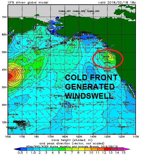
We have a cold front coming through on Monday that will
whip up our SW winds, drop some light showers, and get the surf back to the
head high range by nightfall. If you want to surf and don’t mind a little bump,
that’s all Mother Nature has on tap. Tuesday it’s shoulder high with NW winds
behind the front.

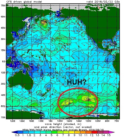
We also have a weak storm off Antarctica today that may give
the OC some waist high SW next Thursday/Friday and not much for San Diego
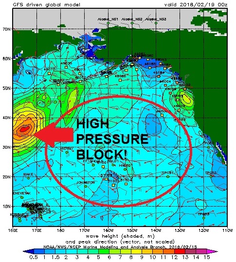
County. High pressure is still in command in the North Pacific and it’s
stunting our swell generation.
Models show a storm forming off Japan next week
that fizzles out before it even gets to Hawaii. With any luck, we may get some
waist to chest high WNW from it next weekend.
And further out, forecast charts
show some disorganized storm activity in the southern hemisphere which may give
us chest high waves the first few days of March.
WEATHER:

Still no big storms on the horizon but we may have a shower
here and there. First up is weak high pressure overhead which will give us
great beach weather tomorrow with temps in the mid-70’s and low 70’s on
Saturday. We have a small cold front coming down that will kick up the low
clouds on Sunday and a chance of showers and windy conditions on Monday. Tuesday
is a transition day then high pressure sets up again for great weather again
mid-week- then maybe another shot of
showers late Thursday and Friday. Feels more like spring than winter.
BEST BET:
Can’t believe I’m saying this… Best Bet is Monday afternoon
with windy, junky, head high storm surf. I guess you gotta take what you can
get right now. Ugh.
NEWS OF THE WEEK:

Nice weather we’re having. Almost too nice. As you know,
I’ve been talking about our dry La Nina weather pattern since last September and what that means for our lack of rain this winter. As luck would have it,
the National Oceanic and Atmospheric Administration is starting to see signs
that the La Nina is finally weakening. Hooray! I think. Let’s have a look at
the changing atmosphere and what’s in store the next few months:

During January, the sea surface temperature in the eastern
tropical (known as the Niño3.4 region- our primary measurement for La Nina/El Nino
activity)- was close to 2 degrees cooler than the long-term average. This
places it comfortably in La Niña territory.
The November–January temperature in the Niño3.4 region was
also 2 degrees cooler than the long-term average. Our second straight year of
La Niña’s has been stronger than the first, as the greatest departure from
average last year was just 1 degree. This
is somewhat unusual for a consecutive year La Niña, as the second year tends to
be a bit weaker than the first.

The atmosphere at this time continues to respond to the
cooler-than-average surface waters in the tropical Pacific. Those cooler-than-average
waters lead to less rising air and cloud formation in the central Pacific than
average (i.e. less of a tropical connection for our storms), with more rising
air and bigger storms forming over the far western Pacific and Indonesia.
More evidence during January was provided by
stronger-than-average near-surface winds (the trade winds), as well as stronger
west-to-east winds in the upper atmosphere. The stronger trade winds help to
keep the surface cooler, and to keep warmer water piled up in the far western Pacific—part
of the critical feedback processes that make up La Nina/El Nino weather
patterns (also known as El Niño-Southern Oscillation or ENSO for short ).
However, this feedback doesn’t go on forever, and we’re seeing signs that La
Niña’s swan song is imminent.
Scientists also keep track of what’s going on under the
surface of the tropical Pacific, as significant temperature changes in the
subsurface waters can provide a valuable clue about the evolution of ENSO
events. From early December to late January, an area of warmer-than-average
water centered between 160–650 feet under the surface traveled from the western
Pacific to the east-central Pacific. This underwater wave chased away most of
the cooler-than-average subsurface waters, leaving La Niña without it’s steady
supply of cooler waters.
This movement toward more neutral subsurface temperatures is
one of the factors forecasters are looking at as we anticipate the decline of
La Niña. Most of the computer models also foresee this transition, and overall
forecasters have come to the consensus of a 55% chance that La Niña conditions
will dissipate by the March–May timeframe, as the tropical Pacific transitions
to neutral conditions.
While this La Niña’s effect on precipitation and temperature
has been generally in-line with expectations over North America, especially
regarding the dry conditions across the southern half of the US, global impacts
haven’t been entirely as expected during the past few months. Unfortunately, by
the time La Nina loosens it’s grip on us, we’ll be head first into spring and
our dry summer season again. Bah-humbug.
PIC OF THE WEEK:

Surfed this spot in the far northwest a few years back. Had
to park my truck in the bushes, just off an old dirt (i.e. muddy) backroad- so
the locals wouldn’t see me- and then hike through the forest 3 miles to get to the
surf. Wore my full suit, booties, and gloves on the sweaty hike so I wouldn’t
brush up against poison oak. Then put my backpack on the beach and surfed for 4
hours while two bear cubs tore apart my lunch and their 500 pound momma bear
kept a watchful eye over me. Dodged an Orca or two then decided to call it a
day before the sun set and hypothermia kicked in. That was the least of my
worries though. I was chased back to my car by Sasquatch only to find it stolen.
Had to hitch hike back the 1,300+ miles home. Luckily got a ride from Large Marge.
True story.
Keep Surfing,
Michael W. Glenn
Keeping It Real
2nd On My Fantasy Olympic Team
0.385 Combined Winning Percentage Vs. Richie Rudolph, Noah
Budroe, and Kelly Gibson