
June Gloom? I'll believe it when I see it.
SURF:
Been an odd start to the year. No real surf from January to April, then not much May Gray/June Gloom so far. Not that I'm complaining as fog is my nemesis. I either like it sunny or stormy. Nothing in-between. On that note, we've got sun and surf this weekend!

Been fun this past week and it's getting better. First up is fun chest high SW/NW the past few days and the water has warmed up to 67 in San Diego. Not exactly El Nino water temps- but we're getting close. As far as the surf this weekend goes, the stars are aligning. You must have been good lately (or lucky). We've got leftover waist to chest high SW on Friday into Saturday and a new NW ground/windswell filling in on Saturday. Best combo spots on Saturday will be shoulder high. Then the fun starts:

We had a solid storm off Antarctica last week send us SW groundswell for Sunday. Look for overhead surf towards north county San Diego into the OC.
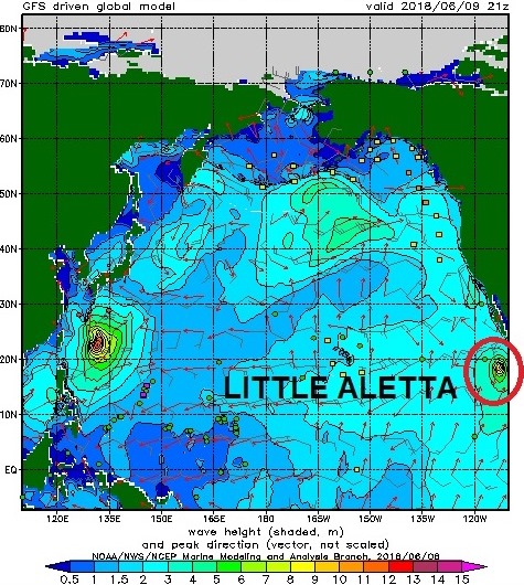
As luck would have it, we also have a small category 1 hurricane off mainland Mexico this afternoon (Aletta) which will give us more S swell on Sunday. Unfortunately the hurricane swell is a waste as the bigger SW swell will override it. If anything, it will just make our surf more consistent.

Tides this weekend are 3.5' at sunrise, down to 1' at lunch, and back up to 5.5' at sunset.
FORECAST:
After the SW swell peaks on Sunday, we still have good head high sets on Monday. For Tuesday, the SW swell won't die and we've got shoulder high sets. By Wednesday it's a shell of it's former self and we're left with chest high surf. Next weekend looks small with just background waist high+ SW/NW. There's been some activity off Antarctica the past few days but nothing solid.


We should get another shot of chest high SW swell around Monday the 18th and shoulder high sets around Wednesday the 22nd. All the while small NW windswell fills in off and on the next week or so. And there's always the possibility of a hurricane flaring up between now and then.
WEATHER:

Great weather on tap the next week with the only fly in the ointment being Sunday. Basically high pressure is keeping the low clouds/fog to a minimum and we've got great beach weather. Look for temps around 75 and WNW winds about 10 mph+ in the afternoons. There's a weak cold front passing by the N on Sunday that may make the clouds linger at the beaches a little longer but nice weather returns for most of next week. Make sure to keep up to date on the latest conditions at Twitter/North County Surf.
BEST BET:
Sunday with solid SW or if you don't like weekend crowds, Monday will be good with slightly smaller surf and sunnier skies.
NEWS OF THE WEEK:

We live in a pretty idyllic place here in southern California. While there's always the threat of earthquakes, we tend to spare the wrath of Mother Nature unlike other locations around the US; volcanic eruptions in Hawaii, hurricanes in Florida, and Nor'Easters in, well, you know, the North East. But most everywhere across America has some sort of natural disaster we need to be ready for. In just the last 16 years alone, parts of Louisiana have been struck by six hurricanes, San Diego have been devastated by three particularly vicious wildfire seasons, and a town in eastern Kentucky has been pummeled by at least nine storms severe enough to warrant federal assistance. The New York Times this week did an article detailing the disasters we've gone through recently and it's eye opening. Here's what they had to say:
Louisiana, San Diego, and Kentucky are just a small fraction of the United States that has sustained most of the damage from major natural disasters, forming a pattern of destruction concentrated in particular areas. About 90 percent of the total losses across the United States occurred in ZIP codes that contain less than 20 percent of the population, according to an analysis of data from the Small Business Administration.

The federal government, through disaster relief programs and flood insurance, subsidizes the cost of rebuilding in areas hit repeatedly by storms, floods and fires. Critics say that encourages too much development in those regions, wasting tens of billions of dollars in tax money and endangering lives. Christina DeConcini, the director of government affairs at the World Resources Institute, said that federal programs do not adequately emphasize adapting to the risks posed by climate change. She said that instead of just being responsive, the government should stress building for resilience against disasters.
Some residents continue living in disaster-stricken areas because they cannot afford to leave. Others rebuff appeals to resettle, citing deep family ties or a sense of fatalism. Rather than move the town, “it’s easier to throw your hands up and say, ‘Forget it,’” said Linda Lowe, the president of a historical society in flood-prone Olive Hill, Ky. “Abandoning a location and moving a city makes sense from a scientific, risk point of view, but the fact is that to get to a place culturally and psychologically where that conversation can be tolerated is a difficult thing to imagine,” said Dr. Irwin Redlener, the director of the National Center for Disaster Preparedness at Columbia University. “It’s not all that rational — but I guess a lot of these things are not really rational.”

As hurricane season begins, residents of Slidell, La., near New Orleans, are planning ahead. Susan McClamroch, who works at a museum there, said that locals joke that they “start eating everything in the freezer” this time of year because of the likelihood of a power failure after a hurricane. Brian Smith, who runs a print shop in Slidell, said the business flooded in 1995 and again during Hurricane Katrina in 2005. So when Hurricane Isaac hit in 2012, flooding his shop once more, he moved it away from the vulnerable downtown area. “I’m not going to take that chance again,” Mr. Smith said.
Eastern Kentucky is similarly susceptible to disaster. Almost yearly, it is hit with severe storms. Susan Thomas, who owns a bookstore and coffee shop in Morehead, Ky., said that the store flooded once when her parents owned it. When it flooded again in 2010, she had to throw away 3,000 books. “Honestly, there was a moment where I was, like, can we recover from this?” she said, adding that she returned to check on the store every time it rained. The business moved to a new location in town the next year.
Three Brothers Bakery in Houston has flooded five times since 2001, most recently during Hurricane Harvey. But its owners, Robert and Janice Jucker, the self-proclaimed “king and queen of disaster,” are not moving — and Ms. Jucker, who anticipates more storms, is unafraid. The Juckers received low-interest disaster loans from the Small Business Administration to rebuild their business after Hurricanes Ike and Harvey. Officials verified the damage and estimated the amount of their property loss.

The agency tracks properties nationwide whose owners or renters applied for disaster loans. Data about these loans provide a window into the geographic pattern of destruction that disasters cause each year. The National Oceanic and Atmospheric Administration attempts to calculate the full cost of major disasters, namely those that cause more than a billion dollars in damages. They estimate that 2017 was the costliest year on record, with 16 billion-dollar disasters that together cost the United States more than $300 billion. "While natural disasters are unpredictable, the annual losses from billion-dollar disasters, adjusted for inflation, have increased over the last 40 years. In the first three months of 2018, billion-dollar storms hit the United States three times. In the first three months of an average year, one disaster that causes more than a billion dollars in damages occurs, according to National Oceanic and Atmospheric Administration records dating back to 1980.
Climate change is making some kinds of disasters more frequent. Studies show that large wildfires have become more common in the western United States because global warming has made Western forests drier. But rising damage costs are partly because of demographic shifts and development decisions that make natural disasters more destructive.
Phil Klotzbach, an atmospheric scientist at Colorado State University, said that the rise in population and wealth near the coast was contributing to most of the increase in destruction caused by hurricanes. In the last century, there has been no clear trend in the frequency of hurricanes that made landfall in the continental United States Over the same period, the number of buildings has ballooned in parts of the country susceptible to tropical storms as the population in those places has also increased. In 2016, there were more than 3.6 times as many homes in states that border the Gulf of Mexico and the Atlantic Ocean as in 1940, according to the Census Bureau.
The effects of global warming on individual storms have been difficult to determine, scientists say, because there are only about a dozen observed even in an active season. But scientists also contend that climate change is expected to lead to stronger, wetter hurricanes over all. It has also made them more destructive, Dr. Klotzbach said. Because global sea levels have risen, hurricanes create storm surges that go further inland, flooding homes and businesses. “You can build your house to withstand pretty much any wind, but the surge is what will get you,” he said. Only about 4 percent of all hurricanes that make landfall globally hit the United States, said Robert Mendelsohn, an economist at Yale University who studies the damage caused by hurricanes. Yet 60 percent of worldwide damage from hurricanes happens in the United States. Dr. Mendelsohn attributed this partly to federal government programs that discourage citizens and local governments from building walls to protect housing near the coast. Only in the United States do relief programs and subsidized insurance make it attractive for people to move toward disaster-prone areas, he said.
PIC OF THE WEEK:

As the SW swells move up the Pacific from Antarctica, they hit South America first, then Central America, then points in Mainland Mexico like this one. With the solid SW swell headed our way for Sunday, what do you think this point looked like today? I could only imagine. For more 'imaginary' pics, check out Bryce Lowe-White's work here.
Keep Surfing,
Michael W. Glenn
Intuitive
Under Promise, Over Deliver
First Person To Surf a Chubasco, Typhoon, Willy-willy, Cyclone, and Hurricane In The Same Year