
If You Love Summer, Raise Your Hand!
SURF:
Just like I'd been saying for months now- sunny, fun surf, warm water, and light winds. (Don't you know sarcasm when you hear it Charlie Brown?)

Anyway, it was worth the wait. Summer finally arrived and conditions came together for the 4th. Surf dropped slightly the past few days, but we still had plenty of everything to go around.
For this weekend, we get a small reinforcement out of the S to keep us in chest high waves along with warm water, partly sunny skies, and manageable winds. I love summer. (I also like stormy winter days but that's a story for another time). And here's the tides, sun, and water temps for the next few days:
- Sunrise and sunset:
- 5:49 AM sunrise.
- 7:59 PM sunset.

- Water temps are finally 70! And they'll stay that way as long as the NW wind doesn't blow and the sun stays out.

- And tides are only an issue in the mornings:
- -0.5' at sunrise
- 3.7' at lunch
- 2.5' late afternoon
- And back to 4' at sunset
FORECAST:

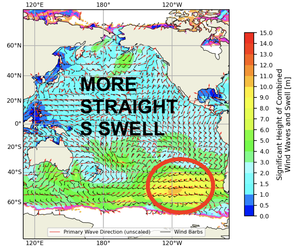
Great surf the past couple weeks will be replaced by fun surf next week. A moderate storm off Antarctica a few days ago has sent more chest high S swell our way for late on Monday into Wedensday morning. The OC will see slightly bigger sets due to the S angle. After that, we could see more chest high SW swell return around the 21st. And no, the tropics aren't doing anything unfortunately.
WEATHER:

Another inland heat wave is baking the deserts with 115 degree heat, 100 in E county, 90 along the 15 freeway, and high 70's at the coast. And Death Valley? Drum roll please... could see 131 degrees this weekend- the highest temperature ever recorded on earth. You heard it here first folks. And if you can't make it to the beach this weekend to cool off in the water, then make sure to hit your local wave pool if you got one. Skies should be partly sunny at the beaches once the fog slowly burns off. High pressure slowly erodes the 2nd half of next week for slightly cooler temperatures. If anything changes between now and then, make sure to follow North County Surf on Twitter!
BEST BET:
This weekend with fun chest high S swell or Tuesday with more fun chest high S swell.
NEWS OF THE WEEK:

As we wait for hurricanes to kick into gear off Mainland Mexico, let's look back at some the Eastern Pacific's greatest hits:
The strongest tropical cyclones are ones that reach Category 5 intensity on the Saffir–Simpson hurricane scale. They are rare in the northeastern Pacific Ocean and generally form only once every several years. In general, Category 5s form in clusters in single years. Landfalls by such storms are rare due to the generally westerly path of tropical cyclones in the Northern Hemisphere. The term "hurricane" is used for tropical cyclones in the Pacific Ocean, north of the equator and east of the International Date Line. A Category 5 Pacific hurricane is therefore a tropical cyclone in the north Pacific Ocean that reached Category 5 intensity east of the International Date Line.
The strongest tropical cyclones are ones that reach Category 5 intensity on the Saffir–Simpson hurricane scale. They are rare in the northeastern Pacific Ocean and generally form only once every several years. In general, Category 5s form in clusters in single years. Landfalls by such storms are rare due to the generally westerly path of tropical cyclones in the Northern Hemisphere. The term "hurricane" is used for tropical cyclones in the Pacific Ocean, north of the equator and east of the International Date Line. A Category 5 Pacific hurricane is therefore a tropical cyclone in the north Pacific Ocean that reached Category 5 intensity east of the International Date Line.
The majority of tropical cyclones form and organize in areas of warm sea surface temperatures, usually of at least 26.5 °C (79.7 °F) and low vertical wind shear. When a pre-existing tropical disturbance – usually a tropical wave or a disturbance originating in the Intertropical Convergence Zone – enters an area where the aforementioned conditions are present, the disturbance can develop into a tropical cyclone, provided it is far enough from the equator to experience a sufficiently strong Coriolis force, which causes the counterclockwise rotation of hurricanes in the Northern Hemisphere. Between the months of December and April, sea surface temperatures in the tropics, where most Northeast Pacific tropical cyclones develop, are usually too low to support significant development. Also, the presence of a semi-permanent high-pressure area known as the North Pacific High in the eastern Pacific greatly reduces tropical cyclone development in the winter months, as the North Pacific High results in vertical wind shear that causes environmental conditions to be non-conducive to tropical cyclone formation. Another factor preventing tropical cyclones from forming during the winter is the presence of a semi-permanent low-pressure area called the Aleutian Low between January and April. Its effects in the central Pacific near the 160th meridian west cause tropical waves that form in the area to move northward into the Gulf of Alaska. As the disturbances travel northward, they dissipate or transition into an extratropical cyclone. The Aleutian Low's retreat in late-April allows the warmth of the Pacific High to meander in, bringing its powerful clockwise wind circulation with it. During the month of May, the Intertropical Convergence Zone migrates southward while vertical shear over the tropics decreases. As a result, the earliest tropical waves begin to form, coinciding with the start of the eastern Pacific hurricane season on May 15. During summer and early autumn, sea surface temperatures rise further, reaching 29 °C (84 °F) in July and August, well above the 26.5 °C (79.7 °F) threshold for the formation and intensification of tropical cyclones. This allows for tropical cyclones developing during that time to strengthen significantly, perhaps even rapidly.
El Niños also influence the frequency and intensity of hurricanes in the Northeast Pacific basin. (Unfortunately for us, this is not one of those years). During El Niño events, sea surface temperatures increase in the Northeast Pacific and vertical wind shear decreases. Because of this, an increase in tropical cyclone activity occurs; the opposite happens in the Atlantic basin during El Niño, where increased wind shear creates an unfavorable environment for tropical cyclone formation (like this year). Contrary to El Niño, La Niña events increase wind shear and decreases sea surface temperatures over the eastern Pacific, while reducing wind shear and increasing sea surface temperatures over the Atlantic.
A Category 5 hurricane is defined as having sustained windspeeds of at least 157 mph (253 km/h) over a one-minute period 10 m (32 ft 10 in) above the ground. As a tropical cyclone is moving, its wind field is asymmetric. In the northern hemisphere, the strongest winds are on the right side of the storm (relative to the direction of motion). The highest winds given in advisories are those from the right side.
Since the 1959 season, only 18 hurricanes are known to have reached Category 5 intensity (that's roughly once every 3 years). There are no known Category 5 storms occurring before 1959. It is possible that some earlier storms reached Category 5 over open waters, but they were never recognized because they never affected land and remained at sea.
The list below shows all Category 5 hurricanes in the order in which they formed. Only 1994's Hurricane Emilia and 2006's Hurricane Ioke have reached Category 5 intensity more than once; that is, by weakening into a Category 4 or weaker storm and later re-strengthening to a Category 5 storm (the gift that keeps on giving).

Before the advent of reliable geostationary satellite coverage in 1966, the number of eastern Pacific tropical cyclones was significantly underestimated. It is therefore very possible that there are additional Category 5 hurricanes other than those listed, but they were not reported and therefore not recognized.
Hurricanes have reached Category 5 intensity during every month from June to October. The earliest Category 5 to form in a season is 1973's Hurricane Ava, which formed on June 7. The latest Category 5 to form in a season is Hurricane Kenna, which reached peak intensity on October 24. Hurricanes Ava, Gilma, Ioke, Linda, and Patricia are the most intense storms to form in their respective months. There have been no May, November, or off-season Category 5 hurricanes.
Two Pacific hurricanes are known to have reached Category 5 intensity multiple times: Emilia and Ioke. Both did it twice, and Ioke reached Category 5 status a third time as a typhoon while in the western Pacific. Hurricane Ioke was tied for the longest-lasting Category 5 hurricane recorded, spending 42 hours at that strength,mwhile hurricanes John and Linda had the longest time spent consecutively at that intensity.

Of all of the Category 5 Pacific hurricanes, the only ones to make landfall at any intensity were Hurricane Kenna, Hurricane Rick, Hurricane Patricia, and Hurricane Willa. None made landfall as Category 5 hurricanes; Patricia and Kenna had weakened to Category 4 status at the time of their landfalls, Willa had weakened to Category 3, and Rick was a tropical storm at its landfall. Patricia was the strongest at landfall among Pacific hurricanes; 1976's Hurricane Madeline and 1992's Hurricane Iniki are tied as the second-strongest storms at landfall, both of which did not reach Category 5 strength, but made landfall as stronger Category 4 storms than Kenna.
In addition to these four systems, hurricanes John, Linda, Ioke, Lane, and Walaka all threatened land at some point during their existence. John, Ioke and Walaka had minimal impacts on Johnston Atoll, John caused heavy surf in Hawaii, and Walaka passed close to East Island in the French Frigate Shoals. Linda was briefly forecast to approach southern California, and it passed close to Socorro Island near peak intensity. Out of the five aforementioned hurricanes, Lane had the most significant impact on land, threatening Hawaii as a major hurricane, and dropping more than 40" (1,000 mm) of rain across many areas. (For comparison's sake, San Diego gets roughly 10" of rain a year).

The reason for the lack of landfalls is that tropical cyclones in the northern hemisphere usually travel to the west. Within the Northeast Pacific, the easterly trade winds cause tropical cyclones to generally move westward out into the open Pacific Ocean. Only rarely do tropical cyclones forming during the peak months of the season make landfall. Closer to the end of the season, the subtropical ridge steers some storms northwards or northeastwards. Storms influenced by this ridge may bring impacts to the western coasts of Mexico and occasionally even Central America. In the central Pacific basin, the North Pacific High keeps tropical cyclones away from the Hawaiian Islands by forcing them southwards. Combined with cooler waters around the Hawaiian Islands that tend to weaken tropical cyclones that approach them, this makes direct impacts on the Hawaiian Islands by tropical cyclones rare.
PIC OF THE WEEK:

I got to surf this spot in Willy Wonka's Chocolate Factory. He calls it 'Skittles Point'. Taste the rainbow!
Keep Surfing,
Michael W. Glenn
Autocrat
I'm Batman
3rd Place, Gilligan's Island Pro, 1967
Michael W. Glenn
Autocrat
I'm Batman
3rd Place, Gilligan's Island Pro, 1967