
So Far So Good. Jinx!
SURF:
Felt good to get some waves finally.
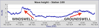
The NW that filled in late Tuesday held through today- and conditions were clean.

For tomorrow, a weak low pressure system will move by to the N of us but it will send a WNW wind/groundswell combo to us late in the day. Look for more shoulder high surf with bigger sets towards SD on Saturday. Sunday will be a touch smaller but still chest high+ surf. And here's the tides, sun, and water temps for the next few days:
- Sunrise and sunset:
- 6:52 AM sunrise
- 4:59 PM sunset (almost 5 PM!)

- Water temps are holding in the high 50's

- And compared to last weekend- the tides are mellow the next few days
- around 2.5' at breakfast
- up to 4' at lunch
- and back down to 0' at sunset
FORECAST:

I think it's about time we turned on the Emergency Boardriding System again. Can you believe the last time I flipped the lever, it was at the end of October? THAT'S OVER 2 MONTHS AGO! That makes me sad. You know what makes me happy though? Surf. And firing surf at that. Models have a few solid swells lined up in the near future- so it's time to put the groveler back in the rafters and dust off that shortboard.

Monday starts off with leftover waist high+ NW then new good WNW fills in Tuesday. Look for head high+ surf late in the day and overhead sets Wednesday morning.


Thursday drops back to head high sets but we get a couple more reinforcements from the WNW on Friday and Sunday for more shoulder to head high surf. If that's the case, we could have good waves for a week! Jinx!

And if the forecast charts hold true, there may be a couple smaller WNW swells the third week of January for more chest (maybe shoulder) high sets. Positive thoughts everyone!
WEATHER:

If you haven't noticed, the past few months have been on again/off again for rain. September was dry, we got a surprise in October with a healthy 1" of rain, November was the driest ever with 0" of rain, and December we had over 3" of rain. So what does that mean for January? Dry so far of course! We have a weak cold front moving by to the N tomorrow which will give us more low clouds/fog and then we're due for beautiful weather again this weekend. Models show a low pressure system moving by to the S of us towards Tuesday next week- and potentially into Baja. If that's the case, we won't see any showers unfortunately. If anything changes between now and then, make sure to follow North County Surf on Twitter!
BEST BET:
Pretty much from late Friday until... not sure! Hopefully we'll have good surf for at least a week with the peak being Tuesday/Wednesday.
NEWS OF THE WEEK:

As mentioned in THE Surf Report throughout 2021, North America is locked into a La Nina weather pattern for the foreseeable future. Normally we'd see below average rainfall and below average/less consistent surf. So far the below average/less consistent surf is holding true and rainfall totals are slightly above average for the time being. Let's cut to the chase though- when are we getting El Nino conditions again? Unfortunately, El Nino weather patterns can wreak havoc across the globe, but for us surfers here in Southern California, it's a blessing in disguise. Such as:
- Above average rainfall in the winter to help our drought
- Above average rainfall in the summer as tropical moisture gets pushed into our region from the Gulf of California
- Above average water temps!
- Above average surf in the winter time as storms roll through Southern California- not pushed into the Pacific NW
- And more hurricane surf in the summer!
But first we need to get back to neutral conditions before El Nino happens. So when is that going to happen? Here's the National Oceanic and Atmospheric Administration on the latest conditions:

La Niña’s hallmark cooler-than-average ocean surface is readily apparent across much of the tropical Pacific. Over the past few weeks, cool anomalies have increased in the eastern Pacific, and in general we see a well-established La Niña pattern. Also characteristic of La Niña is the warmer-than-average surface temperatures in the far western Pacific.
The equatorial eastern Pacific is usually cooler than the water just to the north and south, and cooler than the water in the far western Pacific. (Scientists refer to this region as the “cold tongue,” unfortunately.) This cooler surface right along the equator is due to cold water upwelling from the deep ocean. Any time there is a temperature difference, or gradient, between cold and warm, nature wants to smooth it out, and tropical instability waves help to mix the cooler equatorial surface with the warmer off-equatorial water to the north and south.
During La Niña, the cold tongue is even colder (shudder), so we often see prominent tropical instability wave action. These waves move relatively quickly, so they usually don’t show up in monthly or seasonal sea surface temperature maps.
The sea surface temperature in the Niño-3.4 region of the tropical Pacific, our primary ENSO monitoring index, was about 0.9 °C cooler than the long-term (1991–2020) average. This is according to ERSSTv5, our most reliable dataset, and comfortably within the La Niña category of more than 0.5 °C cooler than average. Forecasters are confident that La Niña will continue for the next few months, partly based on computer model predictions. There is also a large pool of cooler-than-average water under the surface, adding confidence that La Niña’s demise is not imminent.

Forecasters think the most likely scenario is for La Niña to transition to neutral by the late spring. Neutral is the most common state for ENSO in the spring, and most computer models predict the Niño-3.4 Index to be in the neutral range (between -0.5 and 0.5 °C) by the April–June season.
We spend so much time and energy on El Niño and La Niña because they have a substantial impact on winter weather and climate around the globe. (Also, because they’re interesting!) La Niña shifts the Pacific jet stream, the fast-moving river of air that steers storms across North America. Specifically, during La Niña, the jet stream retracts to the west, and an area of high pressure tends to form in the north Pacific. These changes lead to a reduced number of storms coming onshore along the southwestern U.S. coast and hence drier conditions. On the other hand, the storm track tends to get deflected to the north, leading to wetter conditions in the Pacific Northwest.
Since La Niña is linked to drier conditions in the southern tier of the U.S., it can exacerbate drought. The current drought outlook does not expect relief for the severe drought in the Southwest this winter and is anticipating the expansion of drought eastward into Texas and Oklahoma.

Can we make any predictions about the state of ENSO for the winter of 2022–23? Not at the moment. Most of our computer models do not extend out that far, and the evolution from past La Niña events does not give us a clear picture. Overall, of the 12 first-year La Niñas in our historical record, four lasted only one year. Eight turned into double-dip La Niña, just like our current event. Of those, two recurred for a third year (triple-dip?).
One interesting thing to note about La Niña 2020–22 is that, unlike the other 11, it did not follow a full-blown El Niño. The tropical Pacific was warmer than average in 2019–2020 but did not meet El Niño thresholds.
The likelihood of a double-dip La Niña increases for stronger preceding El Niños because the subsurface heat content in the equatorial band is usually more depleted following strong El Niños, providing extra inertia to sustain subsequent surface cooling over multi-year periods. What then accounts for the current 2-year cold event, which was preceded by only very weak El Niño-like warming, is an interesting research topic.
And so, as much as we’d like to get an idea of the next winter, it’s still too soon. The minute forecasters have a clearer picture, though, we’ll pass it on to you!
PIC OF THE WEEK:

Nova Scotia doing its best impression of a cold water Macaronis.
Keep Surfing,
Michael W. Glenn
Sharp As A Tack
Got The Ikon Pass, Disney's Fast Pass, And Taco Bell's Taco Lovers Pass
Guinness Record Holder For Deepest In And Out Barrel @ 38.5' Behind The Lip
Michael W. Glenn
Sharp As A Tack
Got The Ikon Pass, Disney's Fast Pass, And Taco Bell's Taco Lovers Pass
Guinness Record Holder For Deepest In And Out Barrel @ 38.5' Behind The Lip