Most. Rain. Ever.*
SURF:
*Or at least it feels that way. For the amount of rain we've received, you'd think the surf would be bombing; but sometimes the two don't add up. The atmospheric river that's blasted us like a firehose is just that- basically a hose shooting water at us- but not an organized low pressure system.
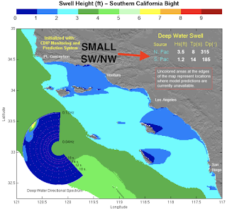
For the weekend, our main source of surf actually will be from the southern hemisphere. Nothing big- but spring is next week- so not unexpected. Look for small SW to arrive late Friday and last into Sunday morning. Best spots in the OC will see chest high sets and far N County SD will be waist high+. And here are tides, sunrise/sunset, and water temps for the next few days:
- Sunrise and sunset:
- 6:55 AM sunrise
- 6:59 PM sunset
- Water temps are slowly inching up to the high 50's in SD.
- Tides have a big swing this weekend:
- 5.5' at sunrise
- down to -1.3' mid-afternoon
- and up to 3' at sunset
FORECAST:
Not much going on Monday, then the next storm rolls in late in the day. As it does, winds will increase from the S, then switch to NW by Wednesday.
In between it all is storm surf in the well overhead range- and lots of rain again.
The 2nd half of the week drops and cleans up, then models show another WNW bearing down on us late in the weekend with most likely rain and wind again. The winter that keeps on giving!
WEATHER:
Not a strong storm this yesterday but LOTS of rain. Most spots along the coast received 2-3" of rain and the Sierras of course received multiple feet of snow. If you've never snowboarded Mammoth Mountain in July, this is going to be your year. But let's focus on the near term. Friday through Sunday look to be mild before the next big rain maker arrives late Monday and lasts into Thursday morning. I'm guessing we could see another 2-3" of rain again. If you haven't fixed the leaks in your roof yet, it's probably too late. Here's a quick rundown on the upcoming week:
- Friday to Sunday: Mostly sunny and temps 65/50
- Monday: Increasing showers late. Temps 60/53
- Tuesday/Wednesday. Rain- maybe another 2-3". Windy. Temps 55/45
- Thursday to Saturday: Cool and sunny. Temps 65/55
- Sunday: More rain late in the day?!
If anything changes between now and then, make sure to follow North County Surf on Twitter!
BEST BET:
Head towards the OC this weekend for small SW. Or if you're up for a challenge (and don't mind getting sick from dirty water), try your luck on Tuesday/Wednesday when it's big and messy...
NEWS OF THE WEEK:
After 20 years of on again off again drought, it's nice to see us above average in the rainfall department. With the 2-3" of rain this week, how's our seasonal totals looking? Let's take a gander:
- Los Angeles: 20.45" so far. That's 196% of normal. FYI- the seasonal average of 12.23" we've already hit that target and blown by it. And this time last year? Only 8.83" of rain!
- Newport Beach: 15.43" so far. That's 160% of normal. And the seasonal total? 11.18". And last year we were at an unbelievably low 5.75"
- Oceanside: 16.24" so far which is 166% of normal for this time of year. Seasonal total we were aiming for? 11.86". And last year at this time was also awful with just 6.11".
- San Diego: 11.82" so far which is 148% of normal. Season total is 9.79" and last year at this time was 5.08".
And if you're wondering, the rainiest year on record for San Diego was 1941 with almost 25" of rain. So if you think this year is wet- just double our total so far this year and that's what you'd get for 1941. Impressive.
In regards to the rain next week- and possibly late next weekend- if we get another 2-3", totals would be:
In regards to the rain next week- and possibly late next weekend- if we get another 2-3", totals would be:
- Los Angeles: possibly 23" (and the rainiest year on record was 1883-1884 with 38")!
- Newport Beach: possibly 18"
- Oceanside: possibly 19"
- San Diego: possibly 15"
On a side note, the Central Sierra Snow Lab has recorded 55.66 feet this season — the seventh snowiest winter on record. The highest-ever amount of snowfall recorded in California was hit in 1938 at 68.24 feet. With the storm(s) next week, they should hit 60 feet. And just think- we're headed towards an El Nino next winter. More snow and rain!


