
Whatever Floats Your Boat
SURF:

Fun surf this week even though the water temps dropped. Again. I give up on my hope of wearing boardshorts this summer. The culprit? Constant NW wind since January. If you don't mind wearing neoprene, than I have some waves to sell you.

First up is a small SW filling in tomorrow for chest high sets in the OC and far N county SD. Not interested? Well... let's talk about Hurricane Hillary.

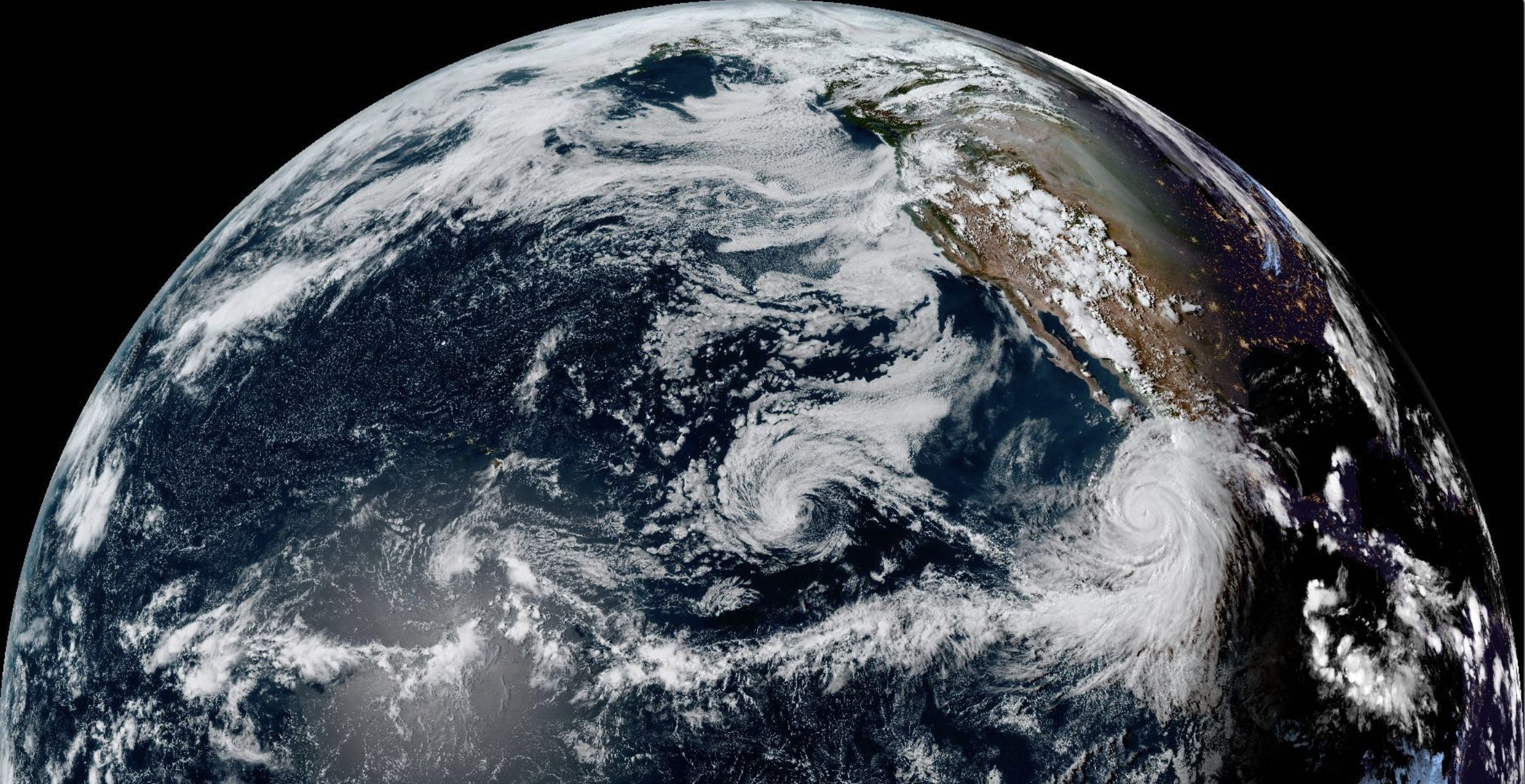
Sitting south of Cabo tonight, Hillary's winds are a respectable 110 mph and headed NW towards southern California. Hillary should peak tomorrow with 140 mph winds- a category 4 hurricane.

Just as she hits our swell window though- she's expected to head due N and into central Baja. What does that mean? Looks like far northern OC will see overhead surf by Sunday and not much for SD. The remnants of Hillary though will drift over California Sunday/Monday with suspect conditions in the form of rain and wind. SD by Monday may see some chest high S windswell from the dissipating storm- so we have that going for us. And here are the tides, sun, and water temps for this weekend:
- Sunrise and sunset this weekend:
- 6:15 AM sunrise
- 7:28 PM sunset

- Water temps:
- Water temps are cooler than they should at 67 degrees. Pray for sun!

- And here's the tides for the weekend:
- 1' at sunrise
- 4.5' at lunch
- and 2' at dinner
FORECAST:
The solid Hillary swell should stick around for the OC on Monday but it may be a little messy. As mentioned above, SD may see some S windswell from Hillary too- but only in the chest high+ range. Things clean up mid-week but the surf looks to be small.

We had a storm form today in the southern hemisphere which will put us back in chest high S swell for SD by next weekend and head high for the OC.

And charts show the tropics and southern hemispher staying active but I don't think our next real swell will arrive until the 1st week of September. If anything changes between now and then, make sure to follow North County Surf on Twitter.
WEATHER:

Who said our weather is boring around here in the summer? (I know, it was me. Don't need to point it out). BUT... it definitely has been an odd summer. First we have fog in August and now it's going to rain cats and dogs next week. If Hillary keeps going N as predicted, look for showers to start as early as Saturday night and then really unload Sunday/Monday. Winds shouldn't be a major problem- maybe 30 mph- which is still impressive for summer. But the amount of rain we could get for late summer is astonishing- up to 2" along the coast and maybe 10"+ in the mountains. Be prepared everyone! Here's what the upcoming week looks like:
- Friday: Maybe a peek of sun late. Air temps 75/65.
- Saturday: Mostly cloudy and a chance of showers. Temps 72/68 (seriously- a 4 degree difference)
- Sunday/Monday: Lots of rain, breezy, and a chance of thunderstorms. Temps 72/68.
- Tuesday through most of next week: A little more sun and a couple tropical clouds overhead. Temps 73/65.
BEST BET:
If you live in the OC, Sunday is the day. If you don't live in the OC, next weekend with fun SW.
NEWS OF THE WEEK:
As mentioned above, Hurricane Hillary will probably max out as a Category 4 storm with 140 mph winds. Pretty impressive. But what is the upper limit of hurricane categories? Is there a category 5, 6, 7, 8, 9, or dare we say... category 10?! Thankfully, the scale only goes to 5, but that doesn't stop a storm from growing as large as it wants (within reason). So how are hurricanes categorized on the scale and what is a category 1 through 5? Well, the National Weather Service has this to say:
The Saffir-Simpson Hurricane Wind Scale is a 1 to 5 rating based on a hurricane's sustained wind speed. This scale estimates potential property damage. Hurricanes reaching Category 3 and higher are considered major hurricanes because of their potential for significant loss of life and damage. Category 1 and 2 storms are still dangerous, however, and require preventative measures. In the western North Pacific, the term "super typhoon" is used for tropical cyclones with sustained winds exceeding 150 mph. Note that all winds are using the U.S. 1-minute average.
The Saffir-Simpson Hurricane Wind Scale is a 1 to 5 rating based on a hurricane's sustained wind speed. This scale estimates potential property damage. Hurricanes reaching Category 3 and higher are considered major hurricanes because of their potential for significant loss of life and damage. Category 1 and 2 storms are still dangerous, however, and require preventative measures. In the western North Pacific, the term "super typhoon" is used for tropical cyclones with sustained winds exceeding 150 mph. Note that all winds are using the U.S. 1-minute average.

Category One Hurricane
Winds 74-95 mph (64-82 kt or 119-153 km/hr). Very dangerous winds will produce some damage: Well-constructed frame homes could have damage to roof, shingles, vinyl siding and gutters. Large branches of trees will snap and shallowly rooted trees may be toppled. Extensive damage to power lines and poles likely will result in power outages that could last a few to several days. Irene of 1999, Katrina of 2005, and several others were Category One hurricanes at landfall in South Florida.
Category Two Hurricane
Winds 96-110 mph (83-95 kt or 154-177 km/hr). Extremely dangerous winds will cause extensive damage: Well-constructed frame homes could sustain major roof and siding damage. Many shallowly rooted trees will be snapped or uprooted and block numerous roads. Near-total power loss is expected with outages that could last from several days to weeks. Frances of 2004 was a Category Two when it hit just north of Palm Beach County, along with at least 10 other hurricanes which have struck South Florida since 1894.
Category Three Hurricane
Winds 111-129 mph (96-112 kt or 178-208 km/hr). Devastating damage will occur: Well-built framed homes may incur major damage or removal of roof decking and gable ends. Many trees will be snapped or uprooted, blocking numerous roads. Electricity and water will be unavailable for several days to weeks after the storm passes. Unnamed hurricanes of 1909, 1910, 1929, 1933, 1945, and 1949 were all Category 3 storms when they struck South Florida, as were King of 1950, Betsy of 1965, Jeanne of 2004, and Irma of 2017.
Category Four Hurricane
Winds 130-156 mph (113-136 kt or 209-251 km/hr). Catastrophic damage will occur: Well-built framed homes can sustain severe damage with loss of most of the roof structure and/or some exterior walls. Most trees will be snapped or uprooted and power poles downed. Fallen trees and power poles will isolate residential areas. Power outages will last weeks to possibly months. Most of the area will be uninhabitable for weeks or months. The 1888, 1900, 1919, 1926 Great Miami, 1928 Lake Okeechobee/Palm Beach, 1947, Donna of 1960 made landfall in South Florida as Category Four hurricanes.
Category Five Hurricane
Winds 157 mph or higher (137 kt or higher or 252 km/hr or higher). Catastrophic damage will occur: A high percentage of framed homes will be destroyed, with total roof failure and wall collapse. Fallen trees and power poles will isolate residential areas. Power outages will last for weeks to possibly months. Most of the area will be uninhabitable for weeks or months. The Keys Hurricane of 1935 and Andrew of 1992 made landfall in South Florida as Category Five hurricanes.
And here's a list of Category 5 hurricanes in the Eastern Pacific (i.e. off the coast of Mexico and Baja):

BEST OF THE BLOG:

PIC OF THE WEEK:

Even though south facing Orange County gets all the credit during hurricane swells (and rightfully so), when all the conditions come together, San Diego can get in on the act too. With far less crowds.
Keep Surfing,
Michael W. Glenn
Head of the Table
Proud Husband of the Birthday Girl
Big Fan of Cyclone, Typhoon, Hurricane, and Willy Willy Swells
Michael W. Glenn
Head of the Table
Proud Husband of the Birthday Girl
Big Fan of Cyclone, Typhoon, Hurricane, and Willy Willy Swells