
Eye Of The Storm
SURF:
Soggy yet? If you live in L.A. you are (more on that below).

Dirty water and storm surf this past week made it a no-go in the surf department. For this weekend, we've got cleaner? conditions and dropping NW for chest high sets.

On Saturday/Sunday, the NW backs off to the waist high+ range but we've got some early season SW for waist high sets too (better towards the OC). The small combo swell should keep us in rideable waves this weekend but much smaller than what we've seen recently. And here’s the sun, tides, and water temps for the upcoming weekend:
- Sunrise and sunset:
- 6:36 AM sunrise (maybe 6 am paddle out?)
- 5:30 PM sunset (maybe 6 pm paddle in?)

- Water temps are 58 due to all the NW wind yesterday

- And tides are fluctuating wildly this weekend:
- about 4' at sunrise
- 6.5' mid-morning
- down to -1.5' late afternoon
- up to 1' at sunset
FORECAST:
High pressure is in control (finally) so the storm door is shut for early next week. Look for nice conditions but only waist high NW if you're lucky.
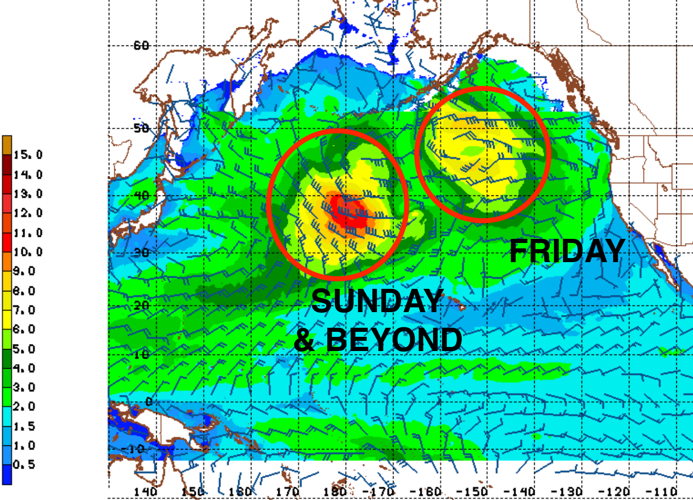
Storms start taking aim at us later in the week so we should see an uptick in WNW towards Friday for shoulder high surf. By late Sunday, if the forecast charts are right, we'll see head high+ WNW again- but deteriorating conditions. And for the work week of February 19th, it could be big again- but rain and wind. If anything changes between now and then, make sure to follow North County Surf on Twitter.
WEATHER:

Looking forward to seeing some of that good ol' sunshine this weekend. But first- a couple more showers tomorrow. High pressure then sets up shop for the foreseeable future and we'll have nice, sunny, cool conditions Saturday 'til Friday. Then... models predict more heavy rain for the week of February 18th. Here's what we have on tap though for the next week:
- Friday: Some stray showers. Temps 57/47
- Saturday: Sunny and cool. Temps 60/42
- Sunday to Friday. Sunny. Temps 62/46.
- And will rain return next weekend and really hit us hard by Monday the 19th?...
BEST BET:
Once the water cleans up, here's some options:
- Saturday with small combo swell and sunny skies.
- Next Friday with new fun WNW and maybe our last day of sun?
NEWS OF THE WEEK:

Multiple storms this week did a doozy in California. Just in Los Angeles alone, the devastating storm caused more than 500 mudslides- and even more throughout southern California- and severely damaged more than 45 homes or buildings, flooded countless roads and forced dozens of evacuations. Statewide, officials have confirmed, nine people died in the storm. Over the last five days, Los Angeles firefighters helped 50 motorists stranded in water and swift water teams rescued five people, including a man who jumped into the roaring Pacoima Wash to save his dog (which also survived), according to the Los Angeles Fire Department. The National Weather Service also reported there was a probable tornado in the Pismo and Grover Beach area Wednesday afternoon, where wind gusts from the storm pushed 60 mph, downing trees and power lines. The Oxnard office of the National Weather Service had not yet confirmed the tornado, but was planning to assess damage to "determine if the damage in this area was due to a tornado, or severe straight-line winds."
If that's not enough, here's some astronomical rain/wind data from the storms this past week:
Rain:
If that's not enough, here's some astronomical rain/wind data from the storms this past week:
Rain:
- Lytle Creek 15.45" (just east of the Interstate 15/215 merge)
- Topanga 14.2" (yes, you read that right)
- Bel Air 13.65"
- Woodland Hills 12.88"
- Mt. Baldy (4300') 10.21"
- Downtown LA 9.03"
- San O' 8.13"
- Coto de Caza 7.4"
- San Onofre 7.28"
- San Juan Capistrano 5.28"
- Laguna Beach 4.8"
- Fallbrook 5.22"
- Oceanside 4.17"
- Encinitas 2.88"
- San Diego Airport 2.68"
- Palm Springs- only 0.88"!
- And as a bonus, Mountain High Ski Resort had almost 4' of snow and Snow Valley a whopping 5'!
- Magic Mountain 83 mph
- Pt. Conception 74 mph
- Catalina Airport 60 mph
- Paso Robles 59 mph
- Topanga 52 mph
- Oceanside 44 mph
- San Diego 35 mph
- Los Angeles: seasonal total of 5.6" on 1/25. Today it's at 13.66" (normal is 7.06"), so we're 193% of normal.
- Newport Beach: seasonal total of 3.65" on 1/25. Today it's at 8.82" (normal is 6.54"), so we're at 135% of normal.
- Oceanside: seasonal total of 5.58" on 1/25. Today it's at 11.25" (normal is 6.31") so we're at 178% of normal.
- San Diego: seasonal total 5.06" on 1/25. Today it's at 8.36" (normal is 5.40") so we're at 155% of normal.
PIC OF THE WEEK:

When these storms finally go away (like in July), I'm hoping to see some of this.
Keep Surfing,
Michael W. Glenn
Beneficial
Making My Return As Left Shark On Sunday
2024 Super Barrelled MVP
Michael W. Glenn
Beneficial
Making My Return As Left Shark On Sunday
2024 Super Barrelled MVP