
Welcome to June Gloom ladies and gentlemen!
SURF:

Had some fun SW swell the past couple days and it's on it's way down tonight. Friday is looking like chest high sets in the far northern part of SD county and waist high+ most everywhere else.


FORECAST:

After a little weekend of surf- it's looking little next week. We have a little storm trying to get it's act together in the southern hemisphere tonight and if it holds, maybe we'll get some waist high+ waves here next Thursday with chest high sets in the OC.


WEATHER:
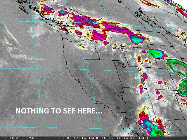
Totally bizarre June Gloom pattern has taken hold the past couple days for the beginning August. Awesome. What should be one of our sunniest/warmest months has instead given us more night/morning low clouds than usual, cold water temps, and cooler than normal air temperatures. Do I sound grumpy? Darn tootin' I am. Anyway, weak low pressure is sitting off the coast of northern California and it's contributing to our June like weather. This should last through the weekend and into next week. Temps will be about 70 in the day and 60 at night. The afternoons have had some sun at the beaches thankfully but it's been a little breezy, a little cool, and not exactly chamber of commerce weather. Thunderstorms in the mountains and deserts have even been squashed for gosh sakes. Hopefully we'll get back on track by next weekend.
BEST BET:
Sunday should be the call as we have a new little SW swell marching our way and nothing much after that...
NEWS OF THE WEEK:

With all this awesome May Gray/June Gloom weather we’re having in August, I thought I’d throw a little salt in the wounds by telling you how great it’s supposed to be around here. August is normally our warmest month with a normal high of 76.8 degrees, a normal low 67.1 degrees and the monthly normal of 71.9 degrees. Extremes since the establishment of the National Weather Service records in 1872 were 98 degrees in 1955 and 54 degrees in 1895. Readings of 80 degrees or higher are far from common and there has been only one day during the entire period with a day of 95 degrees or higher. Rain seldom falls in the city and 60 percent of the August’s have been without a measurable amount. The monthly rainfall average is 0.02 inches and the average number of rainy days with 0.01 inches or more is less than 1. However, in 1977 there was 2.13 inches from the remnants of tropical storm Doreen. Also, in 1873 and 1854 there were 1.95 inches and 1.36 inches respectively. As in the other summer months, thunderstorms have been rare and never severe except in the mountains and deserts. The highest wind recorded at the National Weather Service being only 29 mph. Usually skies become clear by mid-morning and as a result sunshine is plentiful with a monthly mean of 70 percent of possible sunshine and is the 6th sunniest month of the year. Clear days average 15, partly cloudy 12, cloudy 4 and 1 day with heavy fog. There is little change in relative humidity from July, the average being 81 percent in the early morning, 68 percent near noon and 66 percent in the late afternoon.
BEST OF THE BLOG:

Are wavepool parks becoming closer to reality? A group of scientists, business men, and top surf industry executives think they are. So close in fact that they're holding a summit next month to work out the details. Wouldn't it be great to get some waves on your next business trip to Indianapolis? (And yes that is Kelly Slater surfing in Irvine, CA and a surf contest sponsored by L.A. Gear. Totally bitchin'). All of that and more, plus an in depth THE Surf Report in the blog below!
PIC OF THE WEEK:

I love stumbling across pics like this on the internet. Where is this place? How come there's only 3 guys out? Look how round that barrel is! All I can tell you is that the locals have done a good job of keeping this place secret and they'd like to keep it that way.
Keep Surfing,
Michael W. Glenn
Fly
Carlos Danger's Wingman
Created A Surfing Bucket List From A-Frames to Zinka