
Patience is a virtue.
SURF:
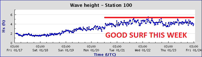
Good surf around here the past few days but that's just an appetizer for this weekend. Did you see the surf report for Kauai yesterday? 35' at 17 seconds. That's big.


FORECAST:

After the bombs this weekend, we get a little break Monday morning before another NW swell hits late in the day. Not as big as the Saturday swell but we'll still have head high sets here in north county SD on Tuesday morning and overhead sets in south SD. After that mother nature takes a breather. Charts show maybe a little NW windswell later in the week but it's nothing worth noting this early in the game.
WEATHER:

No rain in sight. Just fog tomorrow. High pressure kicks in again this weekend and we get sunny skies and temps in the low 70's. Again. We may have a weak cold front move through Northern California the middle of next week which would kick up our low clouds again but until then, we have great weather for the next 5 days- and most likely not a drop of rain for the ENTIRE month of January. Unbelievable.
BEST BET:
Really, you have to ask? Ok, twist my arm- it's Saturday. But you knew that already.
NEWS OF THE WEEK:

The National Climatic Data Center recently came out with their annual report for 2013 and there was good news and bad news. Bad news is that we were warmer than normal (what did you expect). Good news is that we were wetter than normal (this was for the entire US mind you- here in sunny Southern California we were dry as a rock of course). Anyway, the contiguous United States (CONUS) average temperature of 52.4°F was 0.3°F above the 20th century average, and tied with 1980 as the 37th warmest year in the 119-year period of record. The 2013 annual temperature marked the coolest year for the nation since 2009. The 2013 CONUS average temperature was 2.9°F cooler than the 2012 average temperature, which was the warmest year on record for the nation. Since 1895, when national temperature records began, the CONUS has observed a long-term temperature increase of about 0.13°F per decade. Precipitation averaged across the CONUS in 2013 was 31.17 inches, 2.03 inches above the 20th century average. This marked the 21st wettest year on record for the nation and the wettest since 2009. Compared to 2012, which was the 18th driest year on record, the CONUS was 4.50 inches wetter in 2013. Over the 119-year period of record, precipitation across the CONUS increased at an average rate of 0.17 inch per decade.
On a statewide and seasonal level, 2013 was a year of precipitation extremes, with temperature extremes being more muted than the previous year. Above-average temperatures during 2013 were observed in parts of the West, Northeast, and in Florida. No state had annual temperatures that ranked among the ten warmest. California tied its 12th warmest year with a statewide average temperature of 60.3°F, 1.4°F above average. Below-average annual temperatures were observed from the Northern Plains, through the Central Plains and Midwest, and into the Southeast. No state had annual temperatures that ranked among the ten coolest. Despite no state having a record warm or cool year, numerous locations across California and Florida had their warmest year on record, while numerous locations across the Plains and Mid-South had their coolest year on record. A map of those stations is available here. Based on NOAA's Residential Energy Demand Temperature Index (REDTI), the contiguous U.S. temperature-related energy demand during 2013 was 7 percent above average and ranked as the 49th lowest in the 1895-2013 period of record. On a local level during 2013, approximately 26,100 daily warm temperature records were tied or broken (10,100 warm daily maximum records and 16,000 warm daily minimum records); while approximately 28,800 daily cool temperature records were tied or broken (16,900 cool daily maximum records and 11,900 cool daily minimum records).
Overall, much of the CONUS was wetter than average for the year, particularly east of the Rockies. The largest precipitation departures from average were observed in the Northern Plains, the Upper Midwest, and the Southeast. In total 10 states had annual precipitation totals that ranked among the ten wettest years on record. Michigan had its wettest year on record with 40.12 inches of precipitation, 8.9 inches above average. This bested the previous record wet year of 1985 by 0.64 inch. North Dakota also had its wettest year on record with 24.54 inches of precipitation, 7.18 inches above average. This bested the previous record wet year of 2010 by 0.29 inch. In contrast, portions of the West were dry. California had its driest calendar year on record with 7.38 inches of precipitation, 15.13 inches below average. This was 2.42 inches below the previous record dry year of 1898. By the end of 2013, 27.6 percent of California was in Severe Drought. To the north, Oregon had its fourth driest year, while Idaho had its 12th driest. Numerous locations across the Southeast, Midwest, Northern Plains, and Rockies experienced their wettest year on record, while locations in California, Idaho, and Washington had their driest. A map of those stations is available here. In term of drought, according to the U.S. Drought Monitor, conditions improved across much of the southeastern and central U.S. during 2013, but deteriorated in the Far West and Northeast. At the end of 2013, about 31.0 percent of the contiguous U.S. was experiencing drought, down from 61.1 percent at the beginning of the year.
Seasonal highlights in 2013 included:
•The CONUS had its 20th warmest winter on record, with much of the eastern U.S. having above-average temperatures. Florida had its tenth warmest winter on record. Below-average temperatures were observed in parts of the West. The CONUS winter precipitation was above average with wetter-than-average conditions along the Gulf Coast and the western Great Lakes, where seven states had a top ten wet winter season. The winter snow cover extent for the CONUS was 15th largest on record.
• Spring temperatures were cool for the CONUS with a temperature 0.5°F below average. This marked the first season since the winter of 2010/11 with below average CONUS temperatures and this was the coldest spring since 1996. Below-average temperatures were widespread in the central and southeastern U.S., where 14 states had spring temperatures ranking among the ten coolest on record. The West and New England were warmer than average. California had its seventh warmest spring on record. Spring precipitation was near-average nationally, with above-average precipitation in the Upper Midwest and below-average precipitation in much of the West. Iowa had its wettest spring on record, in addition to five additional nearby states having a top 10 wet spring. Below-average spring precipitation was observed in the West and Mid-Atlantic. California and New Mexico had a top 10 dry spring.
• The summer CONUS temperature was above average and tied with 1937 as the 15th warmest summer on record. Above-average temperatures were present in the West and Northeast where nine states had one of the 10 warmest summers on record. Below-average temperatures were observed in the Midwest and Southeast. The summer of 2013 was the eighth wettest on record for the CONUS and the wettest since 2004. Record and near-record wet conditions were observed in the East and Southwest. New York, South Carolina, Georgia, and Florida each had their wettest summer on record.
• The CONUS was slightly warmer than average during autumn, with much of the nation having near-average temperatures. The autumn precipitation total was above average. Near-record wet conditions were observed across the High Plains and Northern Plains, where five states were top 10 wet. California had its 10th driest autumn on record.
If you're looking to kill time at the office, read the entire report here.
PIC OF THE WEEK:

Not exactly the most posh yacht for a boat trip, but hey, it's all about the waves, right?
Keep Surfing,
Michael W. Glenn
Anti-Quitter
Made of Money
Bringin' the El Rollo Back!