
The NW is hibernating while the SW is awakening.
SURF:

The past week saw some fun NW with shots of smaller SW- and intermittent good/bad weather. This weekend will be the same as we have dying NW in the water today with lingering SW swell for chest high sets and clean conditions- for now.


FORECAST:
The work week starts off small as no major storms the past few days will be sending us surf. We have some background SW swells- mainly for the OC that should run waist high+. We had a little area of wind in the southern hemisphere shoot out some swell that will give us waist high waves towards the 9th and chest high sets in the OC.


WEATHER:
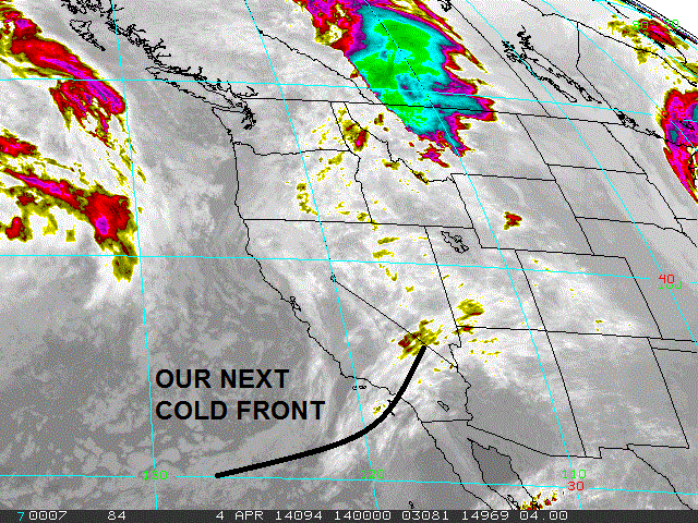
I've said it once but I'll say it a million times again- I'm amazed how nice our winter was here and now spring hits and we get all these cold fronts. As mentioned above, we have a weak cold front coming through today with a 20% chance of showers. Winds will pick up this afternoon from the SW and tomorrow it exits the region- leaving clear cool skies and breezy NW winds. High pressure sets up behind it and we've got temps forecasted at 80 degrees at the beach by Tuesday. Models then hint at another cold front coming through towards the end of the week. Again.
BEST BET:
If you live in SD: NW windswell tomorrow or if you live in the OC: cleaner S swell towards the 2nd half of next week.
NEWS OF THE WEEK:

So it looks like our guaranteed, err, 50% chance El Nino is still on track. Winds in the equatorial Pacific which normally blow east to west have continued to slacked and warm water is pooling up in the eastern half (i.e. our half) of the Pacific, which would give storms (hurricanes and Aleutians) more oomph this fall/winter. The latest from the National Oceanic and Atmospheric Administration says:
• During May-September 2013, well below-average SSTs were observed over the eastern half of the Pacific. (i.e. not good)
• From January- February 2014, SSTs were mostly below average across the eastern equatorial Pacific. (i.e. neither good nor bad)
• In the last week, SSTs were near or above-average across most of the equatorial Pacific Ocean. (i.e. looking good- IF it holds up…)
An increase in positive temperature anomalies occurred during mid-October 2013. A significant decrease in the temperature anomalies, beginning in mid-November 2013, resulted in slightly below-average conditions during January 2014. Since the end of January, temperature anomalies have strongly increased. (i.e. water temperatures have been above average in the central Pacific- and even here for the past couple months- except for that quick cold snap we’re experiencing due to these April cold fronts coming down the coast resulting in upwelling).

NOAA then goes on to say:
• ENSO-neutral conditions continue. (i.e. they still say it’s a 50/50 chance for El Nino to happen this fall winter)
• Equatorial sea surface temperatures (SST) were above-average near the International Date Line and near-average in the east-central Pacific. (as mentioned above)
• ENSO-neutral is expected to continue through the Northern Hemisphere spring 2014, with about a 50% chance of El Niño developing during the summer or fall.
So even though it’s still only a 50% chance of El Nino happening this fall winter, things continue to trend in the right direction.
PIC OF THE WEEK:

Surfing Magazine did a good article recently on San Clemente local Luke Davis and friends doing a jaunt through the Caribbean. Not the biggest waves but empty and looking like heaps of fun. Like today's Pic of the Week- 30 degrees warmer than here and 30 less guys out too. For more picks to get your weekend started, head on over here.
Keep Surfing,
Michael W. Glenn
Undeniable
Waterproof
The New Face of Quiksilver