
Welcome back May Gray!
SURF:
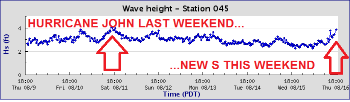
And just like that- the May Gray we were missing in May- shows up in August. Boy is our weather out of whack. Nice to have some cool temps though in August.

As far as our surf went the past few days, we a couple rideable waves show up yesterday in the form of a new S swell- and luckily for us- that will continue to build tomorrow and peak mid-day Friday. Look for chest high+ surf around town and shoulder high+ sets in the OC. Not the biggest but still fun. Saturday will have leftover chest high surf and Sunday will drop to the waist high+ range. Water temps if you haven't noticed, have dropped to the low 70's due to our cloud cover and lack of a heat wave this week. Still good enough for trunks and a jacket.

And tides this weekend are pretty mellow; between 2-3' at sunrise, up to 5' late afternoon, and back down to 3' at sunset.
FORECAST:

As I mentioned in last week's THE Surf Report, the southern hemisphere was on lock down and our only real shot of surf in the near future was going to be from the tropics. Well, Hurricane Lane formed a couple days ago but promptly headed due W to Hawaii (can't really blame him). So in regards to this week's long range forecast, the southern hemisphere is still napping and our only short term shot at waves is from the tropics again. If anything is to form, it won't be for at least 4 or 5 days and we'd get some hurricane surf about 4 days after that. IF, something materializes. So long story short, just look for background knee to waist high SW with NW windswell until at least the 25th of August UNLESS a hurricane forms. And that's a big unless. That doesn't make sense. Confused? So am I. Long story even longer- look for small waves all next week.
WEATHER:

Nothing too exciting in the way of weather this coming week- except for the lightening visible in our inland valleys tonight. That subsides over the weekend and here at the coast we have night/morning low clouds/fog being replaced by afternoon sunshine. Temps will hit high 70's during the day and high 60's at night. The only real action next week is more thunderstorms in the mountains/deserts but models don't show those making it to the coast. So until then, pretty quiet around here until that supposed El Nino hits this winter. Make sure to keep up to date on the latest conditions at Twitter/North County Surf.
BEST BET:
Friday. And then that's it. Forever. Or until a hurricane forms.
NEWS OF THE WEEK:

Even though our water temps have dropped slightly to the mid to low 70's, we're still warmer than average by a few degrees this time of year. Is El Nino to blame? Maybe. The biggest culprits though were that we had above normal air temperatures in July and August as well as the lack of a normal WNW sea breeze. The lack of WNW winds didn't cause any cold upwelling along the CA coast, so the water pooled up along our shores and continued to heat like a bath to a balmy 80 degrees. But did El Nino even contribute slightly? Maybe. According to the National Oceanic and Atmospheric Administration, we're right on track for at least a mild El Nino this winter. Oh boy. Here's what they had to say recently:
By nearly all measurements, forecasters expect our old buddy El Niño will have a 60% chance of appearing this fall, rising to 70% by winter, and the El Niño Watch issued at the beginning of summer continues...

The latest weekly water temp readings in our ever important Niño3.4 region (basically below Hawaii and towards Latin America) were about 0.2 degrees Farenheit above the long-term average. Doesn't seem like much until you realize that we're coming out of a cold La Nina and the El Niño threshold is just 0.9 degrees. The 0.2 degrees is actually a little bit lower than the previous few weeks, but it doesn’t mean that El Niño is less likely. El Niño is a seasonal phenomenon, meaning it’s an average pattern that lasts several months in a row. Weekly fluctuations are expected, and we don’t base our assessments on short-term trends like weekly changes in sea surface temperatures.
The other temperature indexes we follow in the equatorial Pacific are also near normal or slightly above. This includes weekly values of 0.75 degrees above normal in the Niño4 region, 0 in Niño3, and 0.25 in Niño1+2.
So the surface water temps are neutral or slightly above average; what about the all important deep water readings? Well, subsurface heating is still elevated. The temperature under the central-eastern Pacific (between the date line and 100°W longitude, and ~1000 feet deep up to the surface) was 1.5 degrees Farenheit above the long-term average during July- which is a lot of energy to feed into storms this winter.

The surface winds over the tropical Pacific are very important during the development phase of El Niño. This means conditions in the ocean affect the atmosphere, and vice-versa. The normal atmospheric circulation over the Pacific is driven by warm air rising over warm water near Indonesia, west-to-east winds aloft, descending air in the eastern Pacific, and returning east-to-west winds near the surface. Those east-to-west winds help to keep warm water trapped in the far western Pacific, continuing the cycle, and possibly feeding our storms this winter.
During a full-fledged El Niño event, the change in this relationship is clear, and consistent: the warmer-than-average water in the east-central Pacific causes more rising air over that region, changing the circulation from its average pattern. The near-surface east-to-west winds weaken, and may even reverse so they’re blowing from west-to-east, allowing warmer waters to build in the central Pacific.
When El Niño is developing, though, short-term fluctuations in the near-surface winds can have substantial effects. A period of weaker trade winds can help build El Niño’s warmer surface waters, while a period of stronger trade winds can cool the surface and impede El Niño’s growth. It appears that the trade winds are currently weakening (i.e. good), and may continue to do so through the next week, likely helping push things in the El Niño direction.

The latest computer models continue to predict that the sea surface temperature in the Niño3.4 region will cross the El Niño threshold (0.9°F above the long-term average) sometime in the fall. Both the statistical and dynamical computer models generally agree, adding some confidence to the ENSO forecast.
So there you have it. Our water temps may be elevated through the winter which means:
- Trunks into October?
- Only a 3/2 this winter instead of a 4/3?
- More rain hopefully?
- And solid surf! Jinx!
PIC OF THE WEEK:

Peru is famous for:
- Machu Picchu
- The weather phenomenon El Nino was first named here
- Pro surfers Miguel Tudela, Sofia Mulanovich, Felipe Pomar, and Gian Carlos
- Llamas!
- The Andes mountains
- The first known surfers
- Alpacas!
- The highest navigable lake in the world, Lake Titicaca
- Cotahuasi Canyon, the world's deepest at 10,605 feet
- The Atacama desert, which in some parts have only received 1 inch of rain in 30 years
- And loooooooooong left points.
I may have to retire down there.
Keep Surfing,
Michael W. Glenn
The W. Stands For 'Wow'
Caffeine Free
What Do You Call the Last Wave of Your Session? A Wave Goodbye. (I Made That Up. I Got A Million Of 'Em)