
Grasping at straws.
SURF:
Had a good start to our summer but not much since.

Couple fun waves last Friday/Saturday but those were basically an island surrounded by flatness the past few weeks.

The upcoming weekend unfortunately looks to be the same; just some background SW and a touch of NW windswell filling in on Friday for waist high+ surf. That will hold through Sunday. The bright spot lately is that our water is still in the mid-70's. Woohoo!

And tides this weekend are pretty mellow; 2' at sunrise, up to 4' mid-morning, down to 2' again mid-afternoon, and up to, you guessed it, 4' at sunset.
FORECAST:
Still no real storms in the northern and southern hemisphere lately- or on the forecast maps- so another small week of surf we're in for.

We should get a little waist high+ bump from the NW/SW again on Tuesday and models show a small storm taking shape in the southern hemisphere in a couple days which may give us chest high surf from the S towards Wednesday.

And if the forecast charts hold true- maybe shoulder high SW on Labor Day- because you deserve it. Until then, our only real hope again is hurricanes from the tropics, if we can just kickstart it somehow...
WEATHER:

4 weeks 'til fall and we're already starting to transition to a cooler weather pattern. Nothing dramatic, but a distinct pattern change is evolving over the Western Hemisphere as our subtropical high starts to migrate towards the East Coast, resulting in weak cold fronts moving through the West Coast (mainly over the Pacific NW). All in all, we'll have drier, cooler conditions, and more persistent night/morning low clouds/fog with air temps during the day in the mid-70's and lows in the mid 60's at night. Make sure to keep up to date on the changing conditions at Twitter/North County Surf.
BEST BET:
Um, Labor Day, if you can wait that long.
NEWS OF THE WEEK:

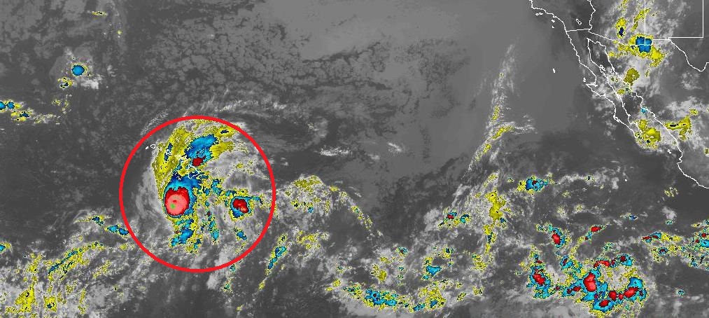
Wanted to give a quick update on Hurricane Lane since it will impact our friends in Hawaii in some capacity. Here's the latest from the National Hurricane Center (NHC) this morning:
Lane remains resilient in the face of increasing southwesterly wind shear, and remains a potent category 4 hurricane. The cloud-filled eye continues to be surrounded by a solid ring of cold cloud tops, with lightning bursts persisting in the northern eye wall for the last several hours. Current wind speeds are 125 knots (143 miles per hour).
Lane continues to make the long-awaited turn toward the northwest, and the forward speed has slowed, with the initial motion for this advisory estimated to be 315 degrees @ 6 knots. Lane has reached the western periphery of a deep-layer ridge, with a trough aloft to the northwest of Hawaii. The steering flow is relatively light and out of the south, and Lane will move northwest and north at a relatively slow speed through Friday in this environment. By 48 to 72 hours, most of the track guidance begins to show a sharp turn toward the west, as the low level circulation of Lane decouples in the face of 35 to 40 kt of shear. Exactly when this critical turn will happen is very difficult to forecast, so confidence in this portion of the track is quite low. The updated track forecast is very close to the previous but has been shifted slightly closer to the islands on days 2 and 3, when Lane will be making its closest point of approach to the islands. Beyond 72 hours, the shallow circulation of Lane is expected to be carried westward away from the islands in the low-level trade wind flow.
Lane is beginning to move underneath increasing shear, analyzed to be near 20 kt, and latest satellite pictures indicate that this may be finally beginning to negatively impact Lane. The shear is expected to remain moderate for the first 24 to 36 hours, then become quite strong beyond 48 hours. A gradual weakening trend is shown through 48 hours, with more rapid weakening beyond that time frame. The intensity forecast remains on the high end of the guidance envelope, but follows closely all of the guidance trends that indicate significant weakening through the forecast period.
Some notes:
1. Lane will pass dangerously close to the main Hawaiian Islands as a hurricane Thursday and Friday, and is expected to bring damaging winds. These winds can be accelerated over and downslope from elevated terrain, and will be higher in high rise buildings.
2. The slow movement of Lane also greatly increases the threat for prolonged heavy rainfall and extreme rainfall totals. This is expected to lead to life-threatening flash flooding and landslides over all Hawaiian Islands.
3. Large and damaging surf can be expected along exposed shorelines, especially along south and west facing coasts, with localized storm surge exacerbating the impacts of a prolonged period of damaging surf.
4. Do not focus on the exact forecast track or intensity of Lane, and be prepared for adjustments to the forecast. Although the official forecast does not explicitly indicate Lane's center making landfall over any of the islands, this could still occur. Even if the center of Lane remains offshore, severe impacts could still be realized as they extend well away from the center.
Forecast positions and max winds:
INIT 23/0900Z 16.3N 156.9W 125 KT 145 MPH
- 12H 23/1800Z 17.2N 157.2W 120 KT 140 MPH
- 24H 24/0600Z 18.4N 157.4W 115 KT 130 MPH
- 36H 24/1800Z 19.5N 157.6W 95 KT 110 MPH
- 48H 25/0600Z 20.2N 158.1W 75 KT 85 MPH
- 72H 26/0600Z 20.4N 160.5W 65 KT 75 MPH
- 96H 27/0600Z 20.0N 163.0W 50 KT 60 MPH
- 120H 28/0600Z 20.5N 166.5W 40 KT 45 MPH
For the latest on the storm's potential impacts, make sure to check out the NHC updates here.
BEST OF THE BLOG:

As you know, I'm part of a group called the North County Board Meeting. No, it's not a cult, but we are highly devoted to surfing. The purpose is to build our community by supporting local businesses, charitable work, networking, and catching a few waves while we're at it. Since we'll have a little waves tomorrow (and our water temps are north of 70 degrees), we'll be having one of our world famous Surf Meetings. Happening from 7-9 AM, we'd like you to come on down to Seaside to catch a wave before work, grab some breakfast, network, get the scoop on our next charity event, and just start the weekend right. Look for the green tent and the demo boards from SUPERbrand! For more info, contact me at northcountyboardmeeting@gmail.com or check out our website here. Hope to see you there!
PIC OF THE WEEK:

Not the biggest, but I'll take it right about now.
Keep Surfing,
Michael W. Glenn
Lofty
Finally Got My Own Wikipedia Page!
Redefining High Performance Surfing. Again.