
Reunited and it feels so good.


From the Eastern Pacific to Hawaii
Two tropical cyclones tracked near Hawaii in 2019: hurricanes Erick and Flossie. Both systems brought high surf to Hawaii, and Erick enhanced rainfall on the Big Island, where several small landslides occurred. Hurricane Lane's Hawaii approach was the 2018 Eastern Pacific tropics' biggest story for the U.S. Lane developed over the Eastern Pacific in August 2018 and crossed into the Central Pacific Ocean. For reference, the dividing line between the Central and Eastern Pacific Ocean basins is 140 degrees west longitude. After intensifying to a Category 5 hurricane southeast of Hawaii, Lane weakened significantly as it passed more than 100 miles south of the island chain. Parts of the islands were swamped by flooding rainfall. Also in 2018, Olivia was the first tropical storm to make landfall over Lanai and Maui. Olivia prompted flooding on Maui and downed trees on Maui and Oahu a few weeks after Lane. Olivia formed in the Eastern Pacific and tracked into the Central Pacific. It weakened before making an unusual approach to Hawaii from the north. In 2014, Hurricane Iselle formed in the Eastern Pacific and moved into the Central Pacific, making landfall on the Big Island of Hawaii as a tropical storm on Aug. 8. There were reports of structural damage, trees downed, power outages and some flooding on the Big Island. Hurricane Iniki in 1992 might be the most serious example of the impacts Eastern Pacific tropical systems can generate in Hawaii. Iniki is the costliest hurricane in Hawaii's history; It originated in the Eastern Pacific on Sept. 5 and moved into the Central Pacific, where it became a powerful hurricane. The island of Kauai was hit especially hard by damaging winds when Iniki made landfall there as a Category 4 storm. Many structures were wiped out by storm surge flooding and large, battering waves along the southern coast. Hawaii is usually protected from tropical storms and hurricanes approaching directly from the east due to cooler waters and strong winds aloft, which contribute to weakening. Many other tropical storms and hurricanes have passed safely to the south of Hawaii because of high pressure north of the islands. It's the rare cases illustrated by Iniki and Lane – when a hurricane first moves south of the island, then arcs northward – that pose a greater threat to the state.
Southwest Tropical Flood Threat
Most Eastern Pacific tropical storms and hurricanes move away from land and are only a concern to shipping interests. But weather patterns at the beginning and end of the season are more conducive to tropical systems that affect Mexico and the southwestern U.S. Arizona is the Southwest state with the history of the most tropical storm encounters. According to the National Weather Service in Tucson, eight tropical storms or depressions have remained intact and impacted Arizona directly since 1965. Five of these were tropical storms with sustained winds of 39 mph or higher. Flooding rainfall is typically the biggest concern from any tropical systems that survive the journey into the southwestern U.S. Systems that are no longer tropical cyclones when they reach the U.S. can still produce flooding rains. While such a storm might no longer be intact, the remnant tropical moisture can fuel drenching rains as it moves into the region. Moisture from both Tropical Storm Ivo and Hurricane Lorena reached the Southwest in 2019. Moisture from Ivo's remnants triggered flash flooding in Las Vegas in late August. Showers and thunderstorms developed in parts of Arizona and New Mexico in response to Lorena's moisture in September. Flash flooding was reported, including near Phoenix. Remnant moisture from four former hurricanes reached areas from the Desert Southwest to Texas in 2018: Bud in June, along with Sergio, Rosa and Willa in October. The interaction between moisture from the remnants of Hurricane Dolores in July 2015 and a disturbance moving into California resulted in historic July rains in Southern California. Both Los Angeles and San Diego broke all-time July rainfall records at a time of year when rainfall is almost always scant in Southern California. San Diego in fact received over an inch of rain from Dolores which is even big for a storm in January! Also in 2015, moisture partially associated with Hurricane Linda led to flooding that killed 20 people in Utah on Sept. 4, according to the National Hurricane Center.

Southern California is the only portion of the Pacific coastline in the Lower 48 that could see a tropical storm or hurricane landfall from the Eastern Pacific. Although such an event is extremely rare, history shows it can happen. On Oct. 2, 1858, the only known hurricane to hit Southern California slammed into San Diego. Sustained hurricane-force winds resulted in extensive property damage. Only one tropical storm has made landfall in Southern California since then. In September 1939, a tropical storm with winds of 50 mph hit Long Beach. Flooding caused moderate crop and structural damage, according to the NWS in Oxnard. High winds surprised the shipping industry in the area, killing 45 people. While technically not a tropical storm at the time, what had been Hurricane Kathleen raced northward into the desert of southeastern California in September 1976. Wind gusts to 76 mph were measured in Yuma, Arizona, and a 4- to 6-foot wall of water destroyed 70 percent of homes in Ocotillo, California.
Cool ocean temperatures in the path of the tropical systems trying to reach the Pacific coast are the primary reason landfalls are so rare in Southern California. Coastal waters get dramatically cooler as you move north along the coast from Mexico. As in 1858, any hurricane would have to be moving fast enough, over waters just warm enough, to maintain its intensity on the way northward in order to have a California landfall. So if history is any indication, just expect good surf from hurricanes in Southern California and not much else.
SURF:

With apologies to Peaches & Herb; darn it's good to see waves again. Regardless of beach access, red tide, and swirling winds, it felt so right to paddle out this week. As luck would have it, we've got more waves coming. Y'all must have been good lately. For Friday, we've got leftover SW ground/NW wind swells for waist to chest high surf and sunny skies.

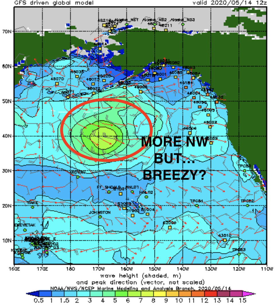
On Saturday we have new SW filling in that will be similar in size to the swell we just had a couple days ago (head high). We should also have more NW windswell to make the beach breaks peaky. Same goes for Sunday. As far as the sun/water temps/tides go, here's what you need to know:
- Sunrise and sunset are:
- 5:49 AM sunrise
- 7:42 PM sunset

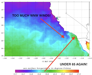
- Water temps in N County are at best mid-60's due to the W wind we've had recently

- And tides are pretty simple this weekend:
- 3.5' at breakfast
- 0.5' at lunch
- 4.5' at dinner
FORECAST:

After a fun weekend of swells, we get more SW/NW on Tuesday BUT... a late season cold front will put a damper on things. Look for it to be fairly junky with a chance of light showers. At least we're not getting mid-May snow in the Sierras.

The cold front exits on Wednesday for a transitional day (i.e. could be windy/could be clean) and we'll have more SW swell for shoulder high surf again and clean conditions.


Next weekend looks small, then we may get more fun shoulder high+ SW around the 25th AND another SW swell at the end of the month. Looks like our early spring surf drought is over?...
BEST BET:
Saturday to Monday before that cold front moves through. Or Wednesday/Thursday AFTER that cold front moves through.
BEST BET:
Saturday to Monday before that cold front moves through. Or Wednesday/Thursday AFTER that cold front moves through.
WEATHER:

Nice weather this week will keep on rolling into Friday/Saturday with slightly above temps and plenty of sun. As mentioned above, we have a late season cold front headed our way and it will increase the low clouds/fog for Sunday, definitely cloudy by Monday, and breezy with a chance of light showers on Tuesday. Wednesday we see the sun again and the 2nd half of next week looks to be early summer weather. Sure beats May Gray, am I right? Make sure to check out Twitter/North County Surf if anything changes between now and then.
NEWS OF THE WEEK:

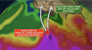
Even though the East Coast of America gets all of the fanfare during the Atlantic hurricane season (rightfully so), here on the Pacific side, there are a few things that could impact us after a storm forms off Mexico. Here's the Weather Channel to explain:
Hurricane season in the Eastern Pacific Basin officially starts Friday, May 15, and the start date is just over two weeks earlier than the official beginning of the Atlantic season. This is due to warmer waters, and the fact that wind shear is typically weaker earlier in the season compared to the Atlantic. The first tropical cyclone of the season has already formed in the Eastern Pacific Ocean. Tropical Depression One-E formed well south of Mexico's Baja California Peninsula on April 25 and became the earliest tropical cyclone on record in the Eastern Pacific Ocean. It did not impact any land areas.
The west coast of Mexico is impacted by Eastern Pacific tropical cyclones each year, and from time to time, very strong hurricanes have struck. In 2015, Hurricane Patricia – with winds up to 215 mph – became the strongest Eastern Pacific hurricane on record before making landfall in Mexico as a Category 4 storm. Additionally, hurricanes and tropical storms that form in the Eastern Pacific can occasionally be a concern for the southwestern U.S. and Hawaii, and there were reminders of this threat in the last several years.
The west coast of Mexico is impacted by Eastern Pacific tropical cyclones each year, and from time to time, very strong hurricanes have struck. In 2015, Hurricane Patricia – with winds up to 215 mph – became the strongest Eastern Pacific hurricane on record before making landfall in Mexico as a Category 4 storm. Additionally, hurricanes and tropical storms that form in the Eastern Pacific can occasionally be a concern for the southwestern U.S. and Hawaii, and there were reminders of this threat in the last several years.

From the Eastern Pacific to Hawaii
Two tropical cyclones tracked near Hawaii in 2019: hurricanes Erick and Flossie. Both systems brought high surf to Hawaii, and Erick enhanced rainfall on the Big Island, where several small landslides occurred. Hurricane Lane's Hawaii approach was the 2018 Eastern Pacific tropics' biggest story for the U.S. Lane developed over the Eastern Pacific in August 2018 and crossed into the Central Pacific Ocean. For reference, the dividing line between the Central and Eastern Pacific Ocean basins is 140 degrees west longitude. After intensifying to a Category 5 hurricane southeast of Hawaii, Lane weakened significantly as it passed more than 100 miles south of the island chain. Parts of the islands were swamped by flooding rainfall. Also in 2018, Olivia was the first tropical storm to make landfall over Lanai and Maui. Olivia prompted flooding on Maui and downed trees on Maui and Oahu a few weeks after Lane. Olivia formed in the Eastern Pacific and tracked into the Central Pacific. It weakened before making an unusual approach to Hawaii from the north. In 2014, Hurricane Iselle formed in the Eastern Pacific and moved into the Central Pacific, making landfall on the Big Island of Hawaii as a tropical storm on Aug. 8. There were reports of structural damage, trees downed, power outages and some flooding on the Big Island. Hurricane Iniki in 1992 might be the most serious example of the impacts Eastern Pacific tropical systems can generate in Hawaii. Iniki is the costliest hurricane in Hawaii's history; It originated in the Eastern Pacific on Sept. 5 and moved into the Central Pacific, where it became a powerful hurricane. The island of Kauai was hit especially hard by damaging winds when Iniki made landfall there as a Category 4 storm. Many structures were wiped out by storm surge flooding and large, battering waves along the southern coast. Hawaii is usually protected from tropical storms and hurricanes approaching directly from the east due to cooler waters and strong winds aloft, which contribute to weakening. Many other tropical storms and hurricanes have passed safely to the south of Hawaii because of high pressure north of the islands. It's the rare cases illustrated by Iniki and Lane – when a hurricane first moves south of the island, then arcs northward – that pose a greater threat to the state.

Southwest Tropical Flood Threat
Most Eastern Pacific tropical storms and hurricanes move away from land and are only a concern to shipping interests. But weather patterns at the beginning and end of the season are more conducive to tropical systems that affect Mexico and the southwestern U.S. Arizona is the Southwest state with the history of the most tropical storm encounters. According to the National Weather Service in Tucson, eight tropical storms or depressions have remained intact and impacted Arizona directly since 1965. Five of these were tropical storms with sustained winds of 39 mph or higher. Flooding rainfall is typically the biggest concern from any tropical systems that survive the journey into the southwestern U.S. Systems that are no longer tropical cyclones when they reach the U.S. can still produce flooding rains. While such a storm might no longer be intact, the remnant tropical moisture can fuel drenching rains as it moves into the region. Moisture from both Tropical Storm Ivo and Hurricane Lorena reached the Southwest in 2019. Moisture from Ivo's remnants triggered flash flooding in Las Vegas in late August. Showers and thunderstorms developed in parts of Arizona and New Mexico in response to Lorena's moisture in September. Flash flooding was reported, including near Phoenix. Remnant moisture from four former hurricanes reached areas from the Desert Southwest to Texas in 2018: Bud in June, along with Sergio, Rosa and Willa in October. The interaction between moisture from the remnants of Hurricane Dolores in July 2015 and a disturbance moving into California resulted in historic July rains in Southern California. Both Los Angeles and San Diego broke all-time July rainfall records at a time of year when rainfall is almost always scant in Southern California. San Diego in fact received over an inch of rain from Dolores which is even big for a storm in January! Also in 2015, moisture partially associated with Hurricane Linda led to flooding that killed 20 people in Utah on Sept. 4, according to the National Hurricane Center.

Southern California is the only portion of the Pacific coastline in the Lower 48 that could see a tropical storm or hurricane landfall from the Eastern Pacific. Although such an event is extremely rare, history shows it can happen. On Oct. 2, 1858, the only known hurricane to hit Southern California slammed into San Diego. Sustained hurricane-force winds resulted in extensive property damage. Only one tropical storm has made landfall in Southern California since then. In September 1939, a tropical storm with winds of 50 mph hit Long Beach. Flooding caused moderate crop and structural damage, according to the NWS in Oxnard. High winds surprised the shipping industry in the area, killing 45 people. While technically not a tropical storm at the time, what had been Hurricane Kathleen raced northward into the desert of southeastern California in September 1976. Wind gusts to 76 mph were measured in Yuma, Arizona, and a 4- to 6-foot wall of water destroyed 70 percent of homes in Ocotillo, California.
Cool ocean temperatures in the path of the tropical systems trying to reach the Pacific coast are the primary reason landfalls are so rare in Southern California. Coastal waters get dramatically cooler as you move north along the coast from Mexico. As in 1858, any hurricane would have to be moving fast enough, over waters just warm enough, to maintain its intensity on the way northward in order to have a California landfall. So if history is any indication, just expect good surf from hurricanes in Southern California and not much else.
PIC OF THE WEEK:

Keep Surfing,
Michael W. Glenn
More Than Capable
High Score, Dig Dug, 35 Years Running.
I Unfortunately Play Guitar Like Peter Townend And Surf Like Pete Townshend