Finally have some fun SW/NW in the water today with peaking SW and a touch of NW. Sets are shoulder high and bigger towards the OC. Beachbreaks are peaky and there's some little barrels out there.
Clouds are breaking up, wind is light from the W and water temps are holding at 70. Looks like it's time for a surf. Beware the tides though! We've got a 0' low tide at sunrise, up to 4' mid-morning, down to 1' after lunch, and up to 6' at sunset.
As the SW starts to back off tomorrow, we've got more NW windswell filling in. Look for wave heights to be about the same as today.
As far as our summer weather goes, we've got the typical night and morning low clouds/fog burning off to mild sunshine in the afternoons with beach temps in the low 70's. There's a weak low pressure system moving by to the north this weekend which will make the low clouds/fog a little more persistent at the coast and temps will be in the high 60's to low 70's. By early next week, high pressure builds again, the low clouds/fog will burn off quicker, and we'll be back to the mid-70's along the coast.
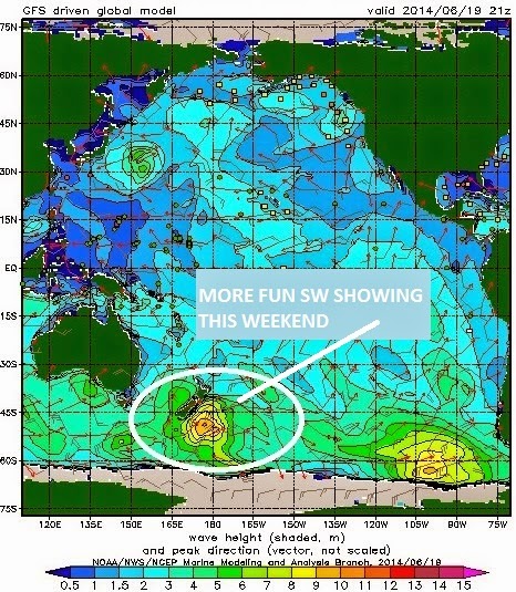
As the current SW backs off the 2nd half of this week, we get more SW towards Friday and into the weekend. Look for more shoulder high sets and overhead waves in the OC.
And the winds off Point Conception pretty much will blow off and on the next few days sending more waist high NW windswell our way which will help peak up the beachbreaks. And the weak cold front that will roll through Northern California this weekend will send a shot of NW groundswell our way early next week. Nothing big but SD should have some chest high+ waves. After that the north and south Pacific take a breather and it looks pretty small the middle of next week. The tropics have also been quiet this past week but that can all change within a few days.