Friday, July 6, 2012
THE Surf Report 7/7/12
Tropic Thunder.
SURF:
Not much surf going on this week. The Fourth of July lacked fireworks with the south wind, cool air temps, flat surf, and cloudy conditions- thank goodness for Pacificos. Today things are starting to turn slightly for the better.
We have some building southern hemi groundswell in the water with inconsistent chest high sets far north SD county and the OC- the negative tide this morning is draining the swell- best to wait 'til mid-day when the tide and swell fills in more. Clouds should even burn off after lunch for a limited time. And the water is high 60's in SD and mid-60's in the OC. SW swell actually peaks tomorrow and holds into Sunday morning with head high sets in the OC and chest high+ waves in SD (bigger in far north county). AND the clouds may actually burn off at the beaches for a lengthy period of time. Can we actually have fun surf coinciding with decent weather?! Oh man! I think I just jinxed us!
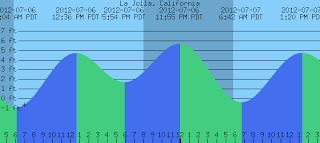
And continue to beware the tides in the mornings! They'll be -1' at sunrise, almost 5' at lunch, and down to 1' at dinner. Make sure to keep up to date on the waves and weather at Twitter/North County Surf.
FORECAST:
After a fun weekend of SW swells, the north Pacific is pretty much dormant next week with no windswell or groundswell in sight. The southern hemisphere also takes a breather with no real storms sending real surf our way for the 2nd half of next week.
Lucky for us though, the tropics are getting into gear and soon to be Hurricane Daniel is chugging along. Now before you get excited, Daniel is only forecasted to be a minimal category 1 hurricane AND it's moving away from us in a westerly direction. But the OC may see some chest high waves late Sunday from it. Going to be kind of hard to tell though with the current SW groundswell too in the water but it should keep the OC into waves through Monday. Models also show some activity off Mainland Mex too but it's still a few days away from turning into anything. Best case scenario is another hurricane by Monday with surf for us by Thursday of next week.
WEATHER:
As advertised above, we finally have a break in the clouds forecasted today through a good portion of next week. High pressure in the central US is trying to expand westward and push our low clouds to sea. We'll still have night and morning low clouds the next few days but at least we'll have beach weather by mid-day.
BEST BET:
Nice beach weather finally tomorrow and some SW swell too? Can summer really be here?!...
NEWS OF THE WEEK:
Now that we're starting to see some life from the tropics this season, I thought it was time we had a refresher course on hurricanes. Hurricanes are giant, spiraling tropical storms that can pack wind speeds of over 160 miles an hour and unleash more than 2.4 trillion gallons of rain a day. These same tropical storms are known as cyclones in the northern Indian Ocean and Bay of Bengal, Willy-Willies in Australia, chubascos in Mexico, and typhoons in the western Pacific Ocean.
Hurricanes begin as tropical disturbances in warm ocean waters with surface temperatures of at least 80 degrees Fahrenheit. These low pressure systems are fed by energy from the warm seas. If a storm achieves wind speeds of 38 miles an hour, it becomes known as a tropical depression. A tropical depression becomes a tropical storm, and is given a name, when its sustained wind speeds top 39 miles an hour. When a storm’s sustained wind speeds reach 74 miles an hour it becomes a hurricane and earns a category rating of 1 to 5 on the Saffir-Simpson scale.
Hurricanes are enormous heat engines that generate energy on a staggering scale. They draw heat from warm, moist ocean air and release it through condensation of water vapor in thunderstorms.
Hurricanes spin around a low-pressure center known as the “eye.” Sinking air makes this 20- to 30-mile-wide (32- to 48-kilometer-wide) area notoriously calm. But the eye is surrounded by a circular “eye wall” that hosts the storm’s strongest winds and rain.
These storms bring destruction ashore in many different ways. When a hurricane makes landfall it often produces a devastating storm surge that can reach 20 feet high and extend nearly 100 miles. Ninety percent of all hurricane deaths result from storm surges.
A hurricane’s high winds are also destructive and may spawn tornadoes. Torrential rains cause further damage by spawning floods and landslides, which may occur many miles inland.
Of course we don't have to worry much about hurricanes here in so-Cal unless we're taking a trip to Cabo, Hawaii, or Typhoon Lagoon in Disneyworld.
BEST OF THE BLOG:
Two of my all-time favorite surfers are Ross Clarke-Jones (a cutback only rivaled by Crammy) and TC (the other Tommy- Carroll that is- who doesn't remember 'The Snap' at Pipeline)?! They've been chasing some monsters in the middle of the ocean during their middle-age and a new film documents it- in 3D no less. Check out the clip on the blog. And of course a mid-week Surf Check and an in depth THE Surf Report. All of that and more in the blog below!
PIC OF THE WEEK:
The Mediterranean is a lot of things- fantastic food, lifestyles of the rich and famous, history galore- but you'd never think surf. Until you see this picture of course. Heck- Lake Tahoe is 22 miles in length and gets some sort of rideable windswell from time to time. With 2400 miles in the Mediterranean, this set up almost looks believable... For more believable pics of Europe, check out the Low Pressure surf guides here.
Keep Surfing,
Michael W. Glenn
Impressionist
Under House Arrest
XXXXXXXXXXXXL Award Winner


