Surf looks fun and I'm outta here.
SURF:
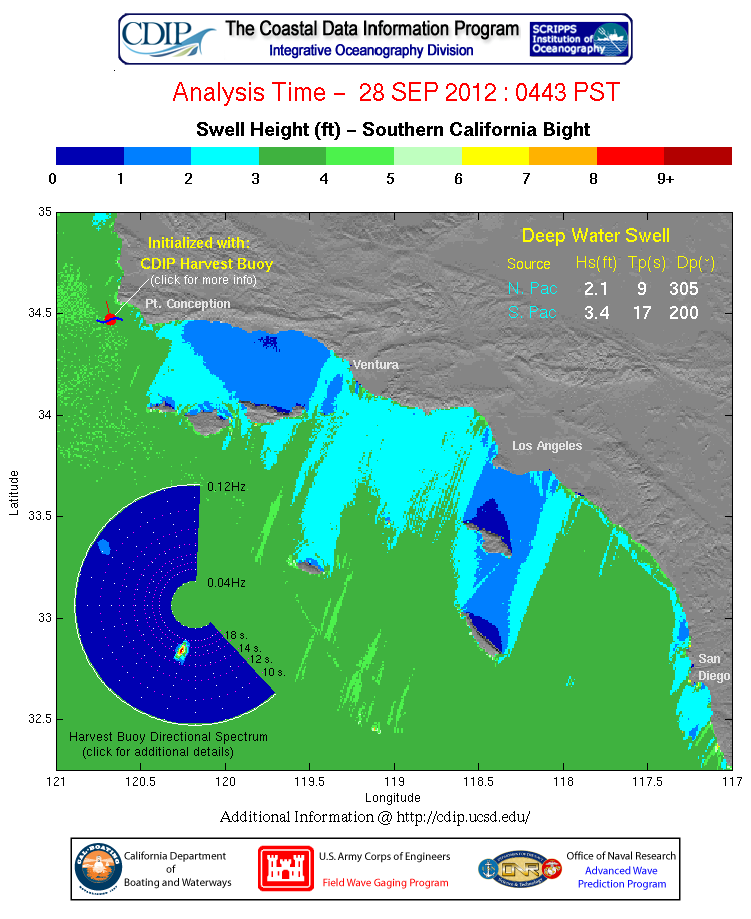
Had some fun surf from the NW/SW and S from Hurricane Miriam this week and the weather cooperated too.


FORECAST:

Not much NW on tap next week- maybe a small bump towards the weekend but nothing has formed yet. Luckily the new SW on Sunday will last a few days 'til Tuesday.


WEATHER:

Great weather on tap today and tomorrow with just minimal low clouds and fog and temps in the high 70's. Then high pressure kicks in and we're slated to have beach temps near 90 by Tuesday. We should see a slight cool off by the 2nd half of the week.
BEST BET:
Sunday morning- holding NW swell, new SW swell, and great weather. And it's not a work day! Beware the extreme tide swings though.
NEWS OF THE WEEK:

And more good news recently about global warming from NOAA (I’m being sarcastic here)…
-August 2012 global temperatures were fourth highest on record-
-Arctic sea ice exceeds all-time lowest extent on record; minimum expected in September-
The globally-averaged temperature for August 2012 marked the fourth warmest August since record keeping began in 1880. August 2012 also marks the 36th consecutive August and 330th consecutive month with a global temperature above the 20th century average.
Most areas of the world experienced much higher-than-average monthly temperatures, including far northeastern North America, central and Southern Europe, and east central Asia. In the Arctic, sea ice extent averaged 1.82 million square miles, resulting in the all-time lowest August sea ice extent on record. On August 26th, the Arctic dipped below the record smallest daily extent, previously set on September 18th, 2007.
The equatorial Pacific Ocean continued to reflect neutral El Niño-Southern Ocean (ENSO) conditions in August. However, according to NOAA's Climate Prediction Center, the El Niño warm ocean phase will likely develop during September. In addition to influencing seasonal climate outcomes in the United States, El Niño is often, but not always, associated with global temperatures that are above the average trend.
August 2012 Selected Climate Anomalies and Events
Global temperature highlights: August
•The combined average temperature over global land and ocean surfaces for August was the fourth highest on record for August, at 61.22°F (16.22°C) or 1.12°F (0.62°C) above the 20th century average. The margin of error associated with this temperature is ±0.16°F (0.09°C).
August 2012 Blended Land & Sea Surface Temperature Anomalies in °C
•August marked the 36th consecutive August and 330th consecutive month with a global temperature above the 20th century average. The last below-average temperature August was August 1976 and the last below-average temperature month was February 1985.
• The global land temperature tied with 2001 and 2011 as the second warmest August on record, behind 1998, at 1.62°F (0.90°C) above the 20th century average of 56.9°F (13.8°C). The margin of error is ±0.32°F (0.18°C).
• Higher-than-average monthly temperatures were most notable across far eastern Canada, southern Greenland, central and southern Europe, western Kazakhstan, Japan, Western Australia, and Paraguay, while temperatures were much cooler than average across parts of Siberia.
•For the ocean, the August global sea surface temperature was 0.94°F (0.52°C) above the 20th century average of 61.4°F (16.4°C), or fifth warmest August on record. This was also the highest monthly global ocean temperature departure from average for any month since July 2010. The margin of error is ±0.07°F (0.04°C).
Polar ice highlights: August
• August 2012's Arctic sea ice extent averaged 1.82 million square miles, which was 38.5 percent below the 1979 to 2000 average. During the month, the Arctic lost an average of 35,400 square miles of ice per day, the fastest rate ever observed for the month of August, resulting in the all-time smallest August Arctic sea ice extent on record.
Arctic and Antarctic sea ice extent, from the August 2012 Global Snow & Ice Report
• According to the National Snow and Ice Data Center, Arctic sea ice shrank to 1.58 million square miles on August 26th, dipping below the smallest extent on record, which occurred on September 18th, 2007 at 1.61 million square miles. By the end of the month, sea ice extent dropped to 1.42 million square miles, with the melt season expected to last until mid-September. All of the six lowest sea ice extents have occurred in the past six years.
•On the opposite pole, Antarctic sea ice during August 2012 was 1.6 percent above average and ranked as fourth largest August extent in the 34-year period of record.
Global temperature highlights: June–August
•The combined average temperature over global land and ocean surfaces for June–August tied with 2005 as the third highest on record for this period at 61.25°F (16.24°C), or 1.15°F (0.64°C), above the 20th century average of 60.1°F (15.6°C). The margin of error associated with this temperature is ±0.16°F (0.09°C).
•The global land temperature was the all-time warmest June–August on record, at 1.85°F (1.03°C) above the 20th century average of 56.9°F (13.8°C). The margin of error is ±0.27°F (0.15°C).
•For the ocean, the June–August global sea surface temperature was 0.90°F (0.50°C), above the 20th century average of 61.5°F (16.4°C), tying with 1997, 2001, and 2002 as the seventh warmest for June–August on record. The margin of error is ±0.07°F (0.04°C).
Global temperature highlights: Year to Date
•Record to near-record warmth over land from April to August and increasing global ocean temperatures in the eastern equatorial Pacific Ocean resulted in the first eight months of 2012 tying with 2006 as the ninth warmest such period on record, with a combined global land and ocean average surface temperature of 1.01°F (0.56°C) above the 20th century average of 57.3°F (14.0°C). The margin of error is ±0.18°F (0.10°C).
Year-to-date temperatures by month, with 2012 compared to the five warmest years on record
•The January–August worldwide land surface temperature was 1.71°F (0.95°C) above the 20th century average, marking the sixth warmest such period on record. The margin of error is ±0.38°F (0.21°C).
•The global ocean surface temperature for the year to date was 0.76°F (0.42°C) above average and ranked as the 11th warmest such period on record. This was the warmest monthly departure from normal since August 2010. The margin of error is ±0.07°F (0.04°C).
I guess the good news is that we’ll be wearing more boardshorts around here. I’m buying Quiksilver stock! For the full report, check it out here.
BEST OF THE BLOG:

SD Magazine has 'discovered' Leucadia this month. Of course you've known about it all along. Just look at the crowds in the line-up lately. Check out the businesses they're profiling and make sure to support them the next time you're out and about. And of course a mid-week Surf Check and an in depth THE Surf Report too- all of that and more in the blog below!
PIC OF THE WEEK:

Nothing fancy. Just a wave in it's simplest form. Of course it's a solid 10' and a barrel big enough to drive a Mac Truck through. But still simple. Kind of.
Keep Surfing,
Michael W. Glenn
Flashy
1st Time Caller
Went Left At Waimea. Switchfoot.